Potrerillo geodata
Potrerillo (Tabasco) is a populated place; located in Mexico in America/Mexico_City (GMT-6) time zone. With population of 1,300 people, there are 6673 cities with bigger population in this country. Compared to other cities in Mexico, 75.5% of cities are located further ↑North; 87.9% of cities are located further ←West and 97.5% of cities have higher elevation than Potrerillo. Note1


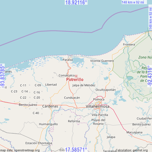
Potrerillo GPS coordinates[2]
18° 15' 16.992" North, 93° 8' 4.992" West
| Map corner | latitude | longitude |
|---|---|---|
| Upper-left | 18.92116°, | -93.83785° |
| Center: | 18.25472°, | -93.13472° |
| Lower-right: | 17.58571°, | -92.4316° |
| Map W x H: | 148.5×148.5 km | = 92.3×92.3mi |
| max Lat: | 32.7° ⇑75.5% North |
| Potrerillo: | 18.25472° |
| min Lat: | ⇓24.5% South 14.53588° |
| min Long | Potrerillo | max Long |
| -117.105° | -93.13472° | -86.73105° |
| W 87.9%⇐ | ⇒12.1% E |
Elevation
Elevation of Potrerillo is 9 m = 30 ft, and this is 1244.7 m = 4084 ft below average elevation for this country.
| Max E: |
3497 m = 11473 ft | 97.5% |
| Avg. | 1253.7 m = 4113 ft | |
| Potrerillo | 9 m = 30 ft | |
Min E: |
-1 m = -3 ft | 2.5% |
See also: Mexico elevation on elevation.city.
Geographical zone
Potrerillo is located in North Torrid zone (between Equator and Tropic of Cancer). Distance of this Northern Tropic circle is 576.2 km =358 mi to North.| Distance of | km | miles | from Potrerillo |
|---|---|---|---|
| North Pole | 7977.3 | 4956.9 | to North |
| Arctic Circle | 5371.4 | 3337.6 | to North |
| Tropic Cancer | 576.2 | 358 | to North |
| Equator | 2029.7 | 1261.2 | to South |


Nearby cities:
15 places around Potrerillo: (largest is in red/bold)
• Ayapa
4.2 km =2.6 mi,  144°
144°
• Chichicapa
5.1 km =3.2 mi,  279°
279°
• Cupilco
1.9 km =1.2 mi,  156°
156°
• El Carmen
4.8 km =3 mi,  202°
202°
• El Novillero
4.5 km =2.8 mi,  96°
96°
• El Recreo
5.3 km =3.3 mi,  56°
56°
• Gobernadores
5.4 km =3.4 mi,  260°
260°
• Jesús Carranza
4.1 km =2.5 mi,  246°
246°
• La Ensenada
5.8 km =3.6 mi,  122°
122°
• Mecoacán
5.9 km =3.7 mi,  107°
107°
• Mecoacán 2da. Sección (San Lorenzo)
5.3 km =3.3 mi, 60°
• Nicolás Bravo
4.2 km =2.6 mi,  5°
5°
• Nicolás Bravo 5ta. Sección (Punta Brava)
2.7 km =1.7 mi, 13°
• Novillero 4ta. Sección
2.3 km =1.4 mi, 117°
• Uspí
1.3 km =0.8 mi, 115°
Sources, notices
• [Note1] Compared only with cities in Mexico existing in our database
• [Src1] Map data: © OpenStreetMap contributors (CC-BY-SA)
• [Src2] Other city data from geonames.org with taken over terms of usage.
• [Src3] Geographical zone / Annual Mean Temperature by Robert A. Rohde @ Wikipedia
