La Rosa geodata
La Rosa (State of Mexico) is a populated place; located in Mexico in America/Mexico_City (GMT-6) time zone. With population of 1,543 people, there are 5591 cities with bigger population in this country. Compared to other cities in Mexico, 54.4% of cities are located further ↑North; 54.6% of cities are located further →East and 93.6% of cities have lower elevation than La Rosa. Note1


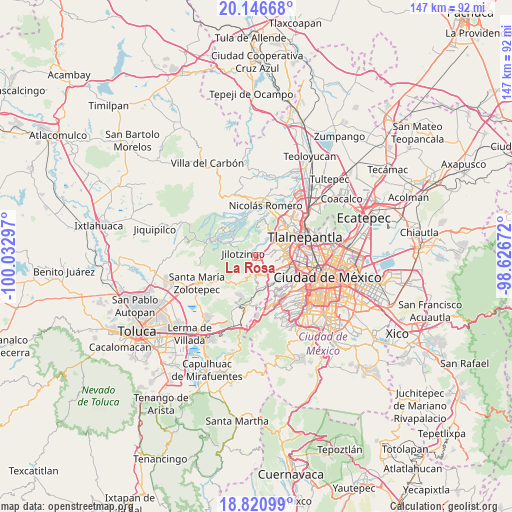
La Rosa GPS coordinates[2]
19° 29' 6.684" North, 99° 19' 47.424" West
| Map corner | latitude | longitude |
|---|---|---|
| Upper-left | 20.14668°, | -100.03297° |
| Center: | 19.48519°, | -99.32984° |
| Lower-right: | 18.82099°, | -98.62672° |
| Map W x H: | 147.4×147.4 km | = 91.6×91.6mi |
| max Lat: | 32.7° ⇑54.4% North |
| La Rosa: | 19.48519° |
| min Lat: | ⇓45.6% South 14.53588° |
| min Long | La Rosa | max Long |
| -117.105° | -99.32984° | -86.73105° |
| W 45.4%⇐ | ⇒54.6% E |
Elevation
Elevation of La Rosa is 2554 m = 8379 ft, and this is 1300.3 m = 4266 ft above average elevation for this country.
| Max E: |
3497 m = 11473 ft | 6.4% |
| La Rosa | 2554 m 8379 ft | |
| Avg. | 1253.7 m = 4113 ft | |
Min E: |
-1 m = -3 ft | 93.6% |
See also: Mexico elevation on elevation.city.
Geographical zone
La Rosa is located in North Torrid zone (between Equator and Tropic of Cancer). Distance of this Northern Tropic circle is 439.4 km =273 mi to North.| Distance of | km | miles | from La Rosa |
|---|---|---|---|
| North Pole | 7840.5 | 4871.9 | to North |
| Arctic Circle | 5234.6 | 3252.6 | to North |
| Tropic Cancer | 439.4 | 273 | to North |
| Equator | 2166.6 | 1346.3 | to South |


Nearby cities:
15 places around La Rosa: (largest is in red/bold)
• Ampliación el Tejocote
4.2 km =2.6 mi,  90°
90°
• Barrio San Miguel Dorami
4.5 km =2.8 mi,  197°
197°
• Barrio de Ensido
4.8 km =3 mi,  281°
281°
• Barrio de Rancho Viejo
1.3 km =0.8 mi, 284°
• Barrio la Cuesta
1.3 km =0.8 mi,  327°
327°
• Barrio las Salinas
5.5 km =3.4 mi, 195°
• Chimalpa Viejo
4.2 km =2.6 mi, 201°
• Ejido del Tejocote
5.4 km =3.4 mi, 90°
• La Hiedra
0.5 km =0.3 mi,  210°
210°
• Llano de las Flores (Barrio del Hueso)
5.5 km =3.4 mi,  172°
172°
• Puente de Piedra
2.8 km =1.7 mi,  64°
64°
• Rincón Verde
4.3 km =2.7 mi,  73°
73°
• San Francisco Chimalpa
4.9 km =3 mi, 197°
• San Luis Ayucán
3.7 km =2.3 mi,  288°
288°
• Santiago Tepatlaxco
1.9 km =1.2 mi,  232°
232°
Sources, notices
• [Note1] Compared only with cities in Mexico existing in our database
• [Src1] Map data: © OpenStreetMap contributors (CC-BY-SA)
• [Src2] Other city data from geonames.org with taken over terms of usage.
• [Src3] Geographical zone / Annual Mean Temperature by Robert A. Rohde @ Wikipedia
