Puente de Piedra geodata
Puente de Piedra (State of Mexico) is a populated place; located in Mexico in America/Mexico_City (GMT-6) time zone. With population of 720 people, there are 12117 cities with bigger population in this country. Compared to other cities in Mexico, 54.1% of cities are located further ↑North; 54.3% of cities are located further →East and 92.6% of cities have lower elevation than Puente de Piedra. Note1


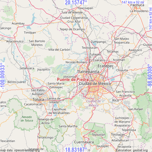
Puente de Piedra GPS coordinates[2]
19° 29' 45.708" North, 99° 18' 22.32" West
| Map corner | latitude | longitude |
|---|---|---|
| Upper-left | 20.15747°, | -100.00933° |
| Center: | 19.49603°, | -99.3062° |
| Lower-right: | 18.83187°, | -98.60308° |
| Map W x H: | 147.4×147.4 km | = 91.6×91.6mi |
| max Lat: | 32.7° ⇑54.1% North |
| Puente de Piedra: | 19.49603° |
| min Lat: | ⇓45.9% South 14.53588° |
| min Long | Puente de Piedr | max Long |
| -117.105° | -99.3062° | -86.73105° |
| W 45.7%⇐ | ⇒54.3% E |
Elevation
Elevation of Puente de Piedra is 2513 m = 8245 ft, and this is 1259.3 m = 4132 ft above average elevation for this country.
| Max E: |
3497 m = 11473 ft | 7.4% |
| Puente de Piedra | 2513 m 8245 ft | |
| Avg. | 1253.7 m = 4113 ft | |
Min E: |
-1 m = -3 ft | 92.6% |
See also: Mexico elevation on elevation.city.
Geographical zone
Puente de Piedra is located in North Torrid zone (between Equator and Tropic of Cancer). Distance of this Northern Tropic circle is 438.2 km =272.3 mi to North.| Distance of | km | miles | from Puente de Piedra |
|---|---|---|---|
| North Pole | 7839.3 | 4871.1 | to North |
| Arctic Circle | 5233.4 | 3251.9 | to North |
| Tropic Cancer | 438.2 | 272.3 | to North |
| Equator | 2167.8 | 1347 | to South |


Nearby cities:
15 places around Puente de Piedra: (largest is in red/bold)
• Ampliación el Tejocote
2.1 km =1.3 mi,  125°
125°
• Barrio San Miguel Dorami
6.7 km =4.2 mi,  214°
214°
• Barrio de Rancho Viejo
3.8 km =2.4 mi,  256°
256°
• Barrio la Cuesta
3.2 km =2 mi,  267°
267°
• Chimalpa Viejo
6.5 km =4 mi,  217°
217°
• Ejido del Tejocote
3.2 km =2 mi,  113°
113°
• Ejido el Castillo
6.7 km =4.2 mi,  179°
179°
• La Hiedra
3.2 km =2 mi,  239°
239°
• La Rosa
2.8 km =1.7 mi, 244°
• Llano de las Flores (Barrio del Hueso)
6.9 km =4.3 mi,  194°
194°
• Naucalpan de Juárez
7.2 km =4.5 mi, 105°
• Rincón Verde
1.6 km =1 mi,  88°
88°
• San Francisco Chimalpa
7.1 km =4.4 mi, 213°
• San Luis Ayucán
6 km =3.7 mi, 269°
• Santiago Tepatlaxco
4.6 km =2.9 mi, 239°
Sources, notices
• [Note1] Compared only with cities in Mexico existing in our database
• [Src1] Map data: © OpenStreetMap contributors (CC-BY-SA)
• [Src2] Other city data from geonames.org with taken over terms of usage.
• [Src3] Geographical zone / Annual Mean Temperature by Robert A. Rohde @ Wikipedia
