Zangarro (Zangarro Nuevo) geodata
Zangarro (Zangarro Nuevo) (Guanajuato) is a populated place; located in Mexico in America/Mexico_City (GMT-6) time zone. With population of 1,360 people, there are 6390 cities with bigger population in this country. Compared to other cities in Mexico, 74.1% of cities are located further ↓South; 75.4% of cities are located further →East and 67.4% of cities have lower elevation than Zangarro (Zangarro Nuevo). Note1
Current local time in Zangarro (Zangarro Nuevo):
10:03 AM, MondayDifference from your time zone: hours


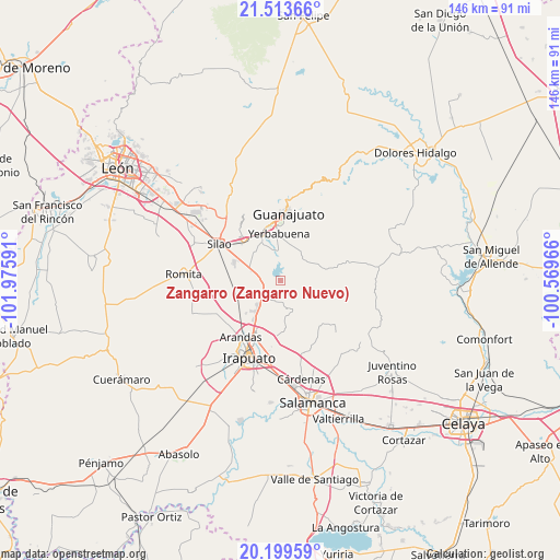
Zangarro (Zangarro Nuevo) GPS coordinates[2]
20° 51' 29.016" North, 101° 16' 22.008" West
| Map corner | latitude | longitude |
|---|---|---|
| Upper-left | 21.51366°, | -101.97591° |
| Center: | 20.85806°, | -101.27278° |
| Lower-right: | 20.19959°, | -100.56966° |
| Map W x H: | 146.1×146.1 km | = 90.8×90.8mi |
| max Lat: | 32.7° ⇑25.9% North |
| Zangarro (Zangarro Nuevo): | 20.85806° |
| min Lat: | ⇓74.1% South 14.53588° |
| min Long | Zangarro (Zanga | max Long |
| -117.105° | -101.27278° | -86.73105° |
| W 24.6%⇐ | ⇒75.4% E |
Elevation
Elevation of Zangarro (Zangarro Nuevo) is 1878 m = 6161 ft, and this is 624.3 m = 2048 ft above average elevation for this country.
| Max E: |
3497 m = 11473 ft | 32.6% |
| Zangarro (Zangarro Nuevo) | 1878 m 6161 ft | |
| Avg. | 1253.7 m = 4113 ft | |
Min E: |
-1 m = -3 ft | 67.4% |
See also: Mexico elevation on elevation.city.
Geographical zone
Zangarro (Zangarro Nuevo) is located in North Torrid zone (between Equator and Tropic of Cancer). Distance of this Northern Tropic circle is 286.7 km =178.1 mi to North.| Distance of | km | miles | from Zangarro (Zangarro Nuevo) |
|---|---|---|---|
| North Pole | 7687.9 | 4777 | to North |
| Arctic Circle | 5082 | 3157.8 | to North |
| Tropic Cancer | 286.7 | 178.1 | to North |
| Equator | 2319.2 | 1441.1 | to South |


Nearby cities:
15 places around Zangarro (Zangarro Nuevo): (largest is in red/bold)
• Aldama
6.4 km =4 mi,  223°
223°
• Cajones
5.7 km =3.5 mi,  5°
5°
• Capulín de Bustos
4.5 km =2.8 mi,  307°
307°
• Cañada de Bustos
6.6 km =4.1 mi,  321°
321°
• Coyote
2.9 km =1.8 mi,  87°
87°
• Cuevas
8 km =5 mi,  345°
345°
• El Tejabán
5.7 km =3.5 mi,  50°
50°
• Hacienda Guadalupe
6 km =3.7 mi,  250°
250°
• La Presita
8 km =5 mi,  358°
358°
• La Trinidad
6.2 km =3.9 mi,  17°
17°
• Los Nicolases
4.6 km =2.9 mi,  270°
270°
• Puentecillas
8.2 km =5.1 mi, 355°
• San Andrés de la Baraña
8 km =5 mi,  287°
287°
• San José de Llanos
3.8 km =2.4 mi, 265°
• San Vicente
7.8 km =4.8 mi, 245°
Sources, notices
• [Note1] Compared only with cities in Mexico existing in our database
• [Src1] Map data: © OpenStreetMap contributors (CC-BY-SA)
• [Src2] Other city data from geonames.org with taken over terms of usage.
• [Src3] Geographical zone / Annual Mean Temperature by Robert A. Rohde @ Wikipedia
