San Miguel del Arenal geodata
San Miguel del Arenal (Guanajuato) is a populated place; located in Mexico in America/Mexico_City (GMT-6) time zone. With population of 1,236 people, there are 7022 cities with bigger population in this country. Compared to other cities in Mexico, 76.3% of cities are located further ↓South; 77.3% of cities are located further →East and 64.1% of cities have lower elevation than San Miguel del Arenal. Note1
Current local time in San Miguel del Arenal:
06:51 AM, WednesdayDifference from your time zone: hours


San Miguel del Arenal GPS coordinates[2]
20° 59' 26.988" North, 101° 29' 8.016" West
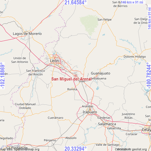
| Map corner | latitude | longitude |
|---|---|---|
| Upper-left | 21.64584°, | -102.18869° |
| Center: | 20.99083°, | -101.48556° |
| Lower-right: | 20.33294°, | -100.78244° |
| Map W x H: | 146×146 km | = 90.7×90.7mi |
| max Lat: | 32.7° ⇑23.7% North |
| San Miguel del Arenal: | 20.99083° |
| min Lat: | ⇓76.3% South 14.53588° |
| min Long | San Miguel del | max Long |
| -117.105° | -101.48556° | -86.73105° |
| W 22.7%⇐ | ⇒77.3% E |
Elevation
Elevation of San Miguel del Arenal is 1803 m = 5915 ft, and this is 549.3 m = 1802 ft above average elevation for this country.
| Max E: |
3497 m = 11473 ft | 35.9% |
| San Miguel del Arenal | 1803 m 5915 ft | |
| Avg. | 1253.7 m = 4113 ft | |
Min E: |
-1 m = -3 ft | 64.1% |
See also: Mexico elevation on elevation.city.
Geographical zone
San Miguel del Arenal is located in North Torrid zone (between Equator and Tropic of Cancer). Distance of this Northern Tropic circle is 272 km =169 mi to North.| Distance of | km | miles | from San Miguel del Arenal |
|---|---|---|---|
| North Pole | 7673.1 | 4767.8 | to North |
| Arctic Circle | 5067.2 | 3148.6 | to North |
| Tropic Cancer | 272 | 169 | to North |
| Equator | 2334 | 1450.3 | to South |


Nearby cities:
15 places around San Miguel del Arenal: (largest is in red/bold)
• Albarradones
5.8 km =3.6 mi,  341°
341°
• Bajío de Bonillas
4.7 km =2.9 mi,  192°
192°
• Colonia Emiliano Zapata (El Cerrito)
2.9 km =1.8 mi,  104°
104°
• Colonia Nuevo México
0.7 km =0.4 mi,  175°
175°
• El Coecillo
4 km =2.5 mi,  113°
113°
• El Refugio de los Sauces
5.4 km =3.4 mi,  299°
299°
• Franco
5.8 km =3.6 mi,  154°
154°
• La Esperanza del Refugio
4.4 km =2.7 mi, 302°
• Loza de Barrera
4.6 km =2.9 mi,  261°
261°
• Mezquite de Sotelo
2.6 km =1.6 mi,  317°
317°
• Monte del Coecillo
5.4 km =3.4 mi, 104°
• Providencia de Nápoles
4.6 km =2.9 mi,  38°
38°
• Salitrillo
5.9 km =3.7 mi,  30°
30°
• San Agustín de las Flores
5.4 km =3.4 mi,  70°
70°
• San Antonio Texas
0.7 km =0.4 mi,  218°
218°
Sources, notices
• [Note1] Compared only with cities in Mexico existing in our database
• [Src1] Map data: © OpenStreetMap contributors (CC-BY-SA)
• [Src2] Other city data from geonames.org with taken over terms of usage.
• [Src3] Geographical zone / Annual Mean Temperature by Robert A. Rohde @ Wikipedia
