El Coecillo geodata
El Coecillo (Guanajuato) is a populated place; located in Mexico in America/Mexico_City (GMT-6) time zone. With population of 4,002 people, there are 2280 cities with bigger population in this country. Compared to other cities in Mexico, 76.2% of cities are located further ↓South; 77% of cities are located further →East and 63.8% of cities have lower elevation than El Coecillo. Note1


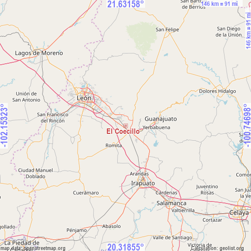
El Coecillo GPS coordinates[2]
20° 58' 35.436" North, 101° 27' 0.36" West
| Map corner | latitude | longitude |
|---|---|---|
| Upper-left | 21.63158°, | -102.15323° |
| Center: | 20.97651°, | -101.4501° |
| Lower-right: | 20.31855°, | -100.74698° |
| Map W x H: | 146×146 km | = 90.7×90.7mi |
| max Lat: | 32.7° ⇑23.8% North |
| El Coecillo: | 20.97651° |
| min Lat: | ⇓76.2% South 14.53588° |
| min Long | El Coecillo | max Long |
| -117.105° | -101.4501° | -86.73105° |
| W 23%⇐ | ⇒77% E |
Elevation
Elevation of El Coecillo is 1796 m = 5892 ft, and this is 542.3 m = 1779 ft above average elevation for this country.
| Max E: |
3497 m = 11473 ft | 36.2% |
| El Coecillo | 1796 m 5892 ft | |
| Avg. | 1253.7 m = 4113 ft | |
Min E: |
-1 m = -3 ft | 63.8% |
See also: Mexico elevation on elevation.city.
Geographical zone
El Coecillo is located in North Torrid zone (between Equator and Tropic of Cancer). Distance of this Northern Tropic circle is 273.5 km =169.9 mi to North.| Distance of | km | miles | from El Coecillo |
|---|---|---|---|
| North Pole | 7674.7 | 4768.8 | to North |
| Arctic Circle | 5068.8 | 3149.6 | to North |
| Tropic Cancer | 273.5 | 169.9 | to North |
| Equator | 2332.4 | 1449.3 | to South |


Nearby cities:
15 places around El Coecillo: (largest is in red/bold)
• Bajío de Bonillas
5.6 km =3.5 mi,  237°
237°
• Colonia Emiliano Zapata (El Cerrito)
1.3 km =0.8 mi,  314°
314°
• Colonia Francisco Javier Mina
3.5 km =2.2 mi,  84°
84°
• Colonia Nuevo México
3.7 km =2.3 mi,  284°
284°
• El Nuevo Condado
5.2 km =3.2 mi,  171°
171°
• Franco
3.9 km =2.4 mi,  198°
198°
• Monte del Coecillo
1.5 km =0.9 mi, 79°
• Pabileros
5.6 km =3.5 mi, 76°
• Providencia de Nápoles
5.2 km =3.2 mi,  351°
351°
• Rancho Seco
3.9 km =2.4 mi,  65°
65°
• San Agustín de las Flores
3.7 km =2.3 mi,  21°
21°
• San Antonio Texas
4.3 km =2.7 mi, 283°
• San Miguel del Arenal
4 km =2.5 mi,  293°
293°
• Silao
4.4 km =2.7 mi,  146°
146°
• Villas de Guadalupe
5.6 km =3.5 mi,  122°
122°
Sources, notices
• [Note1] Compared only with cities in Mexico existing in our database
• [Src1] Map data: © OpenStreetMap contributors (CC-BY-SA)
• [Src2] Other city data from geonames.org with taken over terms of usage.
• [Src3] Geographical zone / Annual Mean Temperature by Robert A. Rohde @ Wikipedia
