Atlamajalcingo del Río geodata
Atlamajalcingo del Río (Guerrero) is a populated place; located in Mexico in America/Mexico_City (GMT-6) time zone. With population of 1,228 people, there are 7063 cities with bigger population in this country. Compared to other cities in Mexico, 82.9% of cities are located further ↑North; 55.6% of cities are located further ←West and 56.2% of cities have higher elevation than Atlamajalcingo del Río. Note1
Current local time in Atlamajalcingo del Río:
08:44 AM, WednesdayDifference from your time zone: hours


Atlamajalcingo del Río GPS coordinates[2]
17° 31' 36.012" North, 98° 39' 20.016" West
| Map corner | latitude | longitude |
|---|---|---|
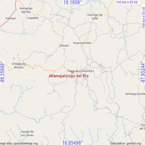
| Upper-left | 18.1959°, | -99.35869° |
| Center: | 17.52667°, | -98.65556° |
| Lower-right: | 16.85496°, | -97.95244° |
| Map W x H: | 149.1×149.1 km | = 92.6×92.6mi |
| max Lat: | 32.7° ⇑82.9% North |
| Atlamajalcingo del Río: | 17.52667° |
| min Lat: | ⇓17.1% South 14.53588° |
| min Long | Atlamajalcingo | max Long |
| -117.105° | -98.65556° | -86.73105° |
| W 55.6%⇐ | ⇒44.4% E |
Elevation
Elevation of Atlamajalcingo del Río is 1150 m = 3773 ft, and this is 103.7 m = 340 ft below average elevation for this country.
| Max E: |
3497 m = 11473 ft | 56.2% |
| Avg. | 1253.7 m = 4113 ft | |
| Atlamajalcingo del Río | 1150 m = 3773 ft | |
Min E: |
-1 m = -3 ft | 43.8% |
See also: Mexico elevation on elevation.city.
Geographical zone
Atlamajalcingo del Río is located in North Torrid zone (between Equator and Tropic of Cancer). Distance of this Northern Tropic circle is 657.1 km =408.3 mi to North.| Distance of | km | miles | from Atlamajalcingo del Río |
|---|---|---|---|
| North Pole | 8058.3 | 5007.2 | to North |
| Arctic Circle | 5452.4 | 3388 | to North |
| Tropic Cancer | 657.1 | 408.3 | to North |
| Equator | 1948.8 | 1210.9 | to South |


Nearby cities:
15 places around Atlamajalcingo del Río: (largest is in red/bold)
• Ahuatepec Ejido
6.4 km =4 mi,  72°
72°
• Aquilpa
6 km =3.7 mi,  289°
289°
• Chiepetepec
9.3 km =5.8 mi,  297°
297°
• Colonia Constitución
6.1 km =3.8 mi,  79°
79°
• La Soledad
5 km =3.1 mi,  62°
62°
• Ocotequila
8.9 km =5.5 mi,  195°
195°
• Oztocingo
4.7 km =2.9 mi,  210°
210°
• San Miguel Axoxuca
2.6 km =1.6 mi,  345°
345°
• San Pedro Petlacala
6.5 km =4 mi,  341°
341°
• Tenango Tepexi
9.2 km =5.7 mi,  12°
12°
• Tlalquetzalapa
7.5 km =4.7 mi,  245°
245°
• Tlapa de Comonfort
8.7 km =5.4 mi, 76°
• Tlaquilzingo
3.8 km =2.4 mi,  125°
125°
• Xalpatlahuac
8.1 km =5 mi,  140°
140°
• Zacatipa
9.4 km =5.8 mi, 134°
Sources, notices
• [Note1] Compared only with cities in Mexico existing in our database
• [Src1] Map data: © OpenStreetMap contributors (CC-BY-SA)
• [Src2] Other city data from geonames.org with taken over terms of usage.
• [Src3] Geographical zone / Annual Mean Temperature by Robert A. Rohde @ Wikipedia
