Tlalquetzalapa geodata
Tlalquetzalapa (Guerrero) is a populated place; located in Mexico in America/Mexico_City (GMT-6) time zone. With population of 810 people, there are 10789 cities with bigger population in this country. Compared to other cities in Mexico, 83.2% of cities are located further ↑North; 54.8% of cities are located further ←West and 56.1% of cities have lower elevation than Tlalquetzalapa. Note1


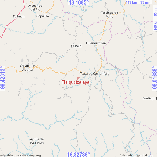
Tlalquetzalapa GPS coordinates[2]
17° 29' 57.012" North, 98° 43' 12" West
| Map corner | latitude | longitude |
|---|---|---|
| Upper-left | 18.1685°, | -99.42313° |
| Center: | 17.49917°, | -98.72° |
| Lower-right: | 16.82736°, | -98.01688° |
| Map W x H: | 149.1×149.1 km | = 92.6×92.6mi |
| max Lat: | 32.7° ⇑83.2% North |
| Tlalquetzalapa: | 17.49917° |
| min Lat: | ⇓16.8% South 14.53588° |
| min Long | Tlalquetzalapa | max Long |
| -117.105° | -98.72° | -86.73105° |
| W 54.8%⇐ | ⇒45.2% E |
Elevation
Elevation of Tlalquetzalapa is 1622 m = 5322 ft, and this is 368.3 m = 1208 ft above average elevation for this country.
| Max E: |
3497 m = 11473 ft | 43.9% |
| Tlalquetzalapa | 1622 m 5322 ft | |
| Avg. | 1253.7 m = 4113 ft | |
Min E: |
-1 m = -3 ft | 56.1% |
See also: Mexico elevation on elevation.city.
Geographical zone
Tlalquetzalapa is located in North Torrid zone (between Equator and Tropic of Cancer). Distance of this Northern Tropic circle is 660.2 km =410.2 mi to North.| Distance of | km | miles | from Tlalquetzalapa |
|---|---|---|---|
| North Pole | 8061.3 | 5009.1 | to North |
| Arctic Circle | 5455.4 | 3389.8 | to North |
| Tropic Cancer | 660.2 | 410.2 | to North |
| Equator | 1945.7 | 1209 | to South |


Nearby cities:
15 places around Tlalquetzalapa: (largest is in red/bold)
• Aquilpa
5.1 km =3.2 mi,  13°
13°
• Atlamajalcingo del Río
7.5 km =4.7 mi,  65°
65°
• Ayotzinapa
7.8 km =4.8 mi,  324°
324°
• Cacahuatepec
5.8 km =3.6 mi,  300°
300°
• Chiepetepec
7.5 km =4.7 mi,  348°
348°
• Colonia la Reforma
8.3 km =5.2 mi,  178°
178°
• Copanatoyac
4 km =2.5 mi,  170°
170°
• Ocotequila
7.1 km =4.4 mi,  140°
140°
• Oztocingo
4.5 km =2.8 mi,  102°
102°
• Patlicha
6.6 km =4.1 mi, 181°
• Potoichán
8.5 km =5.3 mi, 179°
• San Miguel Axoxuca
8.3 km =5.2 mi,  47°
47°
• San Pedro Petlacala
10.4 km =6.5 mi,  27°
27°
• Santa Anita
8.2 km =5.1 mi, 179°
• Tlaquilzingo
9.9 km =6.2 mi,  85°
85°
Sources, notices
• [Note1] Compared only with cities in Mexico existing in our database
• [Src1] Map data: © OpenStreetMap contributors (CC-BY-SA)
• [Src2] Other city data from geonames.org with taken over terms of usage.
• [Src3] Geographical zone / Annual Mean Temperature by Robert A. Rohde @ Wikipedia
