El Progreso geodata
El Progreso (Veracruz) is a populated place; located in Mexico in America/Mexico_City (GMT-6) time zone. With population of 1,094 people, there are 7947 cities with bigger population in this country. Compared to other cities in Mexico, 59.5% of cities are located further ↓South; 74.7% of cities are located further ←West and 82.9% of cities have higher elevation than El Progreso. Note1


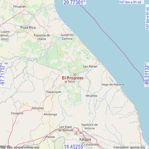
El Progreso GPS coordinates[2]
20° 6' 51.012" North, 97° 0' 51.984" West
| Map corner | latitude | longitude |
|---|---|---|
| Upper-left | 20.77301°, | -97.71757° |
| Center: | 20.11417°, | -97.01444° |
| Lower-right: | 19.45255°, | -96.31132° |
| Map W x H: | 146.8×146.8 km | = 91.2×91.2mi |
| max Lat: | 32.7° ⇑40.5% North |
| El Progreso: | 20.11417° |
| min Lat: | ⇓59.5% South 14.53588° |
| min Long | El Progreso | max Long |
| -117.105° | -97.01444° | -86.73105° |
| W 74.7%⇐ | ⇒25.3% E |
Elevation
Elevation of El Progreso is 61 m = 200 ft, and this is 1192.7 m = 3913 ft below average elevation for this country.
| Max E: |
3497 m = 11473 ft | 82.9% |
| Avg. | 1253.7 m = 4113 ft | |
| El Progreso | 61 m = 200 ft | |
Min E: |
-1 m = -3 ft | 17.1% |
See also: Mexico elevation on elevation.city.
Geographical zone
El Progreso is located in North Torrid zone (between Equator and Tropic of Cancer). Distance of this Northern Tropic circle is 369.4 km =229.5 mi to North.| Distance of | km | miles | from El Progreso |
|---|---|---|---|
| North Pole | 7770.6 | 4828.4 | to North |
| Arctic Circle | 5164.7 | 3209.2 | to North |
| Tropic Cancer | 369.4 | 229.5 | to North |
| Equator | 2236.5 | 1389.7 | to South |


Nearby cities:
15 places around El Progreso: (largest is in red/bold)
• Arroyo del Potrero
6.3 km =3.9 mi,  303°
303°
• El Faisán
7.9 km =4.9 mi,  3°
3°
• Felipe Carrillo Puerto
7 km =4.3 mi,  69°
69°
• La Colmena
4 km =2.5 mi,  161°
161°
• La Defensa
5.7 km =3.5 mi,  100°
100°
• La Piedrilla
1.9 km =1.2 mi,  169°
169°
• La Unión Paso Largo
3.5 km =2.2 mi,  25°
25°
• Martínez de la Torre
6.8 km =4.2 mi,  225°
225°
• María de la Torre
2.6 km =1.6 mi,  49°
49°
• Máximo García
5.2 km =3.2 mi,  115°
115°
• Plan de Limón
7.4 km =4.6 mi, 157°
• Pueblo Viejo Dos
6.5 km =4 mi,  185°
185°
• Salvador Díaz Mirón
7.6 km =4.7 mi,  334°
334°
• Villa Independencia
7.6 km =4.7 mi,  210°
210°
• Villanueva
2.4 km =1.5 mi,  179°
179°
Sources, notices
• [Note1] Compared only with cities in Mexico existing in our database
• [Src1] Map data: © OpenStreetMap contributors (CC-BY-SA)
• [Src2] Other city data from geonames.org with taken over terms of usage.
• [Src3] Geographical zone / Annual Mean Temperature by Robert A. Rohde @ Wikipedia
