Villanueva geodata
Villanueva (Veracruz) is a populated place; located in Mexico in America/Mexico_City (GMT-6) time zone. With population of 820 people, there are 10646 cities with bigger population in this country. Compared to other cities in Mexico, 59% of cities are located further ↓South; 74.7% of cities are located further ←West and 84.8% of cities have higher elevation than Villanueva. Note1


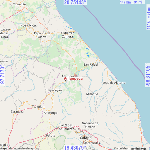
Villanueva GPS coordinates[2]
20° 5' 33" North, 97° 0' 51.012" West
| Map corner | latitude | longitude |
|---|---|---|
| Upper-left | 20.75143°, | -97.7173° |
| Center: | 20.0925°, | -97.01417° |
| Lower-right: | 19.43079°, | -96.31105° |
| Map W x H: | 146.8×146.8 km | = 91.2×91.2mi |
| max Lat: | 32.7° ⇑41% North |
| Villanueva: | 20.0925° |
| min Lat: | ⇓59% South 14.53588° |
| min Long | Villanueva | max Long |
| -117.105° | -97.01417° | -86.73105° |
| W 74.7%⇐ | ⇒25.3% E |
Elevation
Elevation of Villanueva is 45 m = 148 ft, and this is 1208.7 m = 3966 ft below average elevation for this country.
| Max E: |
3497 m = 11473 ft | 84.8% |
| Avg. | 1253.7 m = 4113 ft | |
| Villanueva | 45 m = 148 ft | |
Min E: |
-1 m = -3 ft | 15.2% |
See also: Mexico elevation on elevation.city.
Geographical zone
Villanueva is located in North Torrid zone (between Equator and Tropic of Cancer). Distance of this Northern Tropic circle is 371.8 km =231 mi to North.| Distance of | km | miles | from Villanueva |
|---|---|---|---|
| North Pole | 7773 | 4829.9 | to North |
| Arctic Circle | 5167.1 | 3210.7 | to North |
| Tropic Cancer | 371.8 | 231 | to North |
| Equator | 2234.1 | 1388.2 | to South |


Nearby cities:
15 places around Villanueva: (largest is in red/bold)
• Arroyo del Potrero
7.9 km =4.9 mi,  317°
317°
• Colonias Pedernales
6.5 km =4 mi,  216°
216°
• El Progreso
2.4 km =1.5 mi,  359°
359°
• La Colmena
1.9 km =1.2 mi,  138°
138°
• La Defensa
5.7 km =3.5 mi,  75°
75°
• La Libertad
6.1 km =3.8 mi, 135°
• La Piedrilla
0.6 km =0.4 mi,  29°
29°
• La Unión Paso Largo
5.7 km =3.5 mi,  15°
15°
• Martínez de la Torre
5.4 km =3.4 mi,  243°
243°
• María de la Torre
4.5 km =2.8 mi, 25°
• Máximo García
4.7 km =2.9 mi,  87°
87°
• Palpoalanixcan
7.1 km =4.4 mi,  110°
110°
• Plan de Limón
5.2 km =3.2 mi,  147°
147°
• Pueblo Viejo Dos
4.1 km =2.5 mi,  189°
189°
• Villa Independencia
5.7 km =3.5 mi, 223°
Sources, notices
• [Note1] Compared only with cities in Mexico existing in our database
• [Src1] Map data: © OpenStreetMap contributors (CC-BY-SA)
• [Src2] Other city data from geonames.org with taken over terms of usage.
• [Src3] Geographical zone / Annual Mean Temperature by Robert A. Rohde @ Wikipedia
