San Isidro Palotal geodata
San Isidro Palotal (Veracruz) is a populated place; located in Mexico in America/Mexico_City (GMT-6) time zone. With population of 1,077 people, there are 8093 cities with bigger population in this country. Compared to other cities in Mexico, 66% of cities are located further ↑North; 75.3% of cities are located further ←West and 59.4% of cities have higher elevation than San Isidro Palotal. Note1


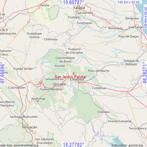
San Isidro Palotal GPS coordinates[2]
18° 56' 39.012" North, 96° 57' 56.988" West
| Map corner | latitude | longitude |
|---|---|---|
| Upper-left | 19.60787°, | -97.66896° |
| Center: | 18.94417°, | -96.96583° |
| Lower-right: | 18.27782°, | -96.26271° |
| Map W x H: | 147.9×147.9 km | = 91.9×91.9mi |
| max Lat: | 32.7° ⇑66% North |
| San Isidro Palotal: | 18.94417° |
| min Lat: | ⇓34% South 14.53588° |
| min Long | San Isidro Palo | max Long |
| -117.105° | -96.96583° | -86.73105° |
| W 75.3%⇐ | ⇒24.7% E |
Elevation
Elevation of San Isidro Palotal is 1031 m = 3383 ft, and this is 222.7 m = 731 ft below average elevation for this country.
| Max E: |
3497 m = 11473 ft | 59.4% |
| Avg. | 1253.7 m = 4113 ft | |
| San Isidro Palotal | 1031 m = 3383 ft | |
Min E: |
-1 m = -3 ft | 40.6% |
See also: Mexico elevation on elevation.city.
Geographical zone
San Isidro Palotal is located in North Torrid zone (between Equator and Tropic of Cancer). Distance of this Northern Tropic circle is 499.5 km =310.4 mi to North.| Distance of | km | miles | from San Isidro Palotal |
|---|---|---|---|
| North Pole | 7900.7 | 4909.3 | to North |
| Arctic Circle | 5294.8 | 3290 | to North |
| Tropic Cancer | 499.5 | 310.4 | to North |
| Equator | 2106.4 | 1308.9 | to South |


Nearby cities:
15 places around San Isidro Palotal: (largest is in red/bold)
• Berlín
5.4 km =3.4 mi,  121°
121°
• Córdoba (Santa Leticia)
4.2 km =2.6 mi,  199°
199°
• El Palenque Palotal
3 km =1.9 mi,  331°
331°
• El Porvenir
4.9 km =3 mi, 121°
• Fortín de las Flores
5.4 km =3.4 mi,  221°
221°
• Fraccionamiento Villas de la Llave
4.1 km =2.5 mi, 220°
• Fraccionamiento los Álamos
2.5 km =1.6 mi, 203°
• La Palma (Tercera Manzana del Barreal)
2 km =1.2 mi,  259°
259°
• Residencial Cecadys
3.7 km =2.3 mi,  169°
169°
• San José de Abajo [Unidad Habitacional]
2.7 km =1.7 mi,  175°
175°
• San Rafael Calería
2.3 km =1.4 mi,  100°
100°
• Santa Clara (Camino al Lienzo Charro)
3.2 km =2 mi, 176°
• Santa Martina
2.7 km =1.7 mi,  211°
211°
• Santa Teresita (Segunda Manzana del Barreal)
2 km =1.2 mi,  191°
191°
• Tecama Calería (Sabana Larga)
4.1 km =2.5 mi,  342°
342°
Sources, notices
• [Note1] Compared only with cities in Mexico existing in our database
• [Src1] Map data: © OpenStreetMap contributors (CC-BY-SA)
• [Src2] Other city data from geonames.org with taken over terms of usage.
• [Src3] Geographical zone / Annual Mean Temperature by Robert A. Rohde @ Wikipedia
