El Porvenir geodata
El Porvenir (Veracruz) is a populated place; located in Mexico in America/Mexico_City (GMT-6) time zone. With population of 1,243 people, there are 6982 cities with bigger population in this country. Compared to other cities in Mexico, 66.5% of cities are located further ↑North; 75.8% of cities are located further ←West and 61.6% of cities have higher elevation than El Porvenir. Note1


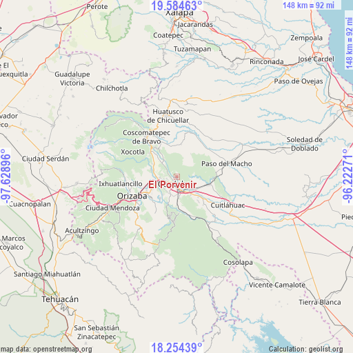
El Porvenir GPS coordinates[2]
18° 55' 14.988" North, 96° 55' 32.988" West
| Map corner | latitude | longitude |
|---|---|---|
| Upper-left | 19.58463°, | -97.62896° |
| Center: | 18.92083°, | -96.92583° |
| Lower-right: | 18.25439°, | -96.22271° |
| Map W x H: | 147.9×147.9 km | = 91.9×91.9mi |
| max Lat: | 32.7° ⇑66.5% North |
| El Porvenir: | 18.92083° |
| min Lat: | ⇓33.5% South 14.53588° |
| min Long | El Porvenir | max Long |
| -117.105° | -96.92583° | -86.73105° |
| W 75.8%⇐ | ⇒24.2% E |
Elevation
Elevation of El Porvenir is 902 m = 2959 ft, and this is 351.7 m = 1154 ft below average elevation for this country.
| Max E: |
3497 m = 11473 ft | 61.6% |
| Avg. | 1253.7 m = 4113 ft | |
| El Porvenir | 902 m = 2959 ft | |
Min E: |
-1 m = -3 ft | 38.4% |
See also: Mexico elevation on elevation.city.
Geographical zone
El Porvenir is located in North Torrid zone (between Equator and Tropic of Cancer). Distance of this Northern Tropic circle is 502.1 km =312 mi to North.| Distance of | km | miles | from El Porvenir |
|---|---|---|---|
| North Pole | 7903.3 | 4910.9 | to North |
| Arctic Circle | 5297.4 | 3291.7 | to North |
| Tropic Cancer | 502.1 | 312 | to North |
| Equator | 2103.8 | 1307.2 | to South |


Nearby cities:
15 places around El Porvenir: (largest is in red/bold)
• Agustín Millán
3.9 km =2.4 mi,  171°
171°
• Berlín
0.5 km =0.3 mi,  124°
124°
• Córdoba
4.1 km =2.5 mi,  179°
179°
• Córdoba (Santa Leticia)
5.7 km =3.5 mi,  256°
256°
• Fraccionamiento los Álamos
5.2 km =3.2 mi,  273°
273°
• Miguel Aguilar
3.4 km =2.1 mi,  52°
52°
• Residencial Cecadys
3.7 km =2.3 mi,  252°
252°
• San Isidro Palotal
4.9 km =3 mi,  301°
301°
• San José de Abajo [Unidad Habitacional]
4 km =2.5 mi, 268°
• San Matías
0.8 km =0.5 mi, 169°
• San Rafael Calería
2.9 km =1.8 mi,  318°
318°
• Santa Clara (Camino al Lienzo Charro)
4.1 km =2.5 mi, 261°
• Santa Martina
5.6 km =3.5 mi, 273°
• Santa Teresita (Segunda Manzana del Barreal)
4.6 km =2.9 mi,  278°
278°
• Zacatepec
5.8 km =3.6 mi,  205°
205°
Sources, notices
• [Note1] Compared only with cities in Mexico existing in our database
• [Src1] Map data: © OpenStreetMap contributors (CC-BY-SA)
• [Src2] Other city data from geonames.org with taken over terms of usage.
• [Src3] Geographical zone / Annual Mean Temperature by Robert A. Rohde @ Wikipedia
