Tres M (Pérez) geodata
Tres M (Pérez) (Baja California) is a populated place; located in Mexico in America/Tijuana (GMT-7) time zone. With population of 917 people, there are 9514 cities with bigger population in this country. Compared to other cities in Mexico, 99.8% of cities are located further ↓South; 99.8% of cities are located further →East and 75.7% of cities have higher elevation than Tres M (Pérez). Note1


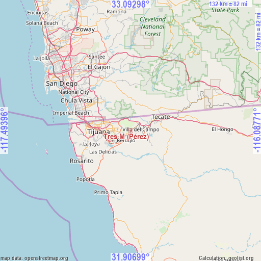
Tres M (Pérez) GPS coordinates[2]
32° 30' 6.984" North, 116° 47' 26.988" West
| Map corner | latitude | longitude |
|---|---|---|
| Upper-left | 33.09298°, | -117.49396° |
| Center: | 32.50194°, | -116.79083° |
| Lower-right: | 31.90699°, | -116.08771° |
| Map W x H: | 131.9×131.9 km | = 82×82mi |
| max Lat: | 32.7° ⇑0.2% North |
| Tres M (Pérez): | 32.50194° |
| min Lat: | ⇓99.8% South 14.53588° |
| min Long | Tres M (Pérez) | max Long |
| -117.105° | -116.79083° | -86.73105° |
| W 0.2%⇐ | ⇒99.8% E |
Elevation
Elevation of Tres M (Pérez) is 199 m = 653 ft, and this is 1054.7 m = 3460 ft below average elevation for this country.
| Max E: |
3497 m = 11473 ft | 75.7% |
| Avg. | 1253.7 m = 4113 ft | |
| Tres M (Pérez) | 199 m = 653 ft | |
Min E: |
-1 m = -3 ft | 24.3% |
See also: Mexico elevation on elevation.city.
Geographical zone
Tres M (Pérez) is located in North temperate zone (between Tropic of Cancer and the Arctic Circle). Distance of this Northern Tropic circle is 1008 km =626.3 mi to South.| Distance of | km | miles | from Tres M (Pérez) |
|---|---|---|---|
| North Pole | 6393.2 | 3972.5 | to North |
| Arctic Circle | 3787.3 | 2353.3 | to North |
| Tropic Cancer | 1008 | 626.3 | to South |
| Equator | 3613.9 | 2245.6 | to South |


Nearby cities:
15 places around Tres M (Pérez): (largest is in red/bold)
• Batalla Nacional
4.1 km =2.5 mi,  224°
224°
• Ejido Javier Rojo Gómez
3.1 km =1.9 mi,  253°
253°
• Ejido Ojo de Agua
2.9 km =1.8 mi,  176°
176°
• El Niño
0.6 km =0.4 mi,  350°
350°
• Lomas de Santa Anita
13.8 km =8.6 mi,  70°
70°
• Lomas de Tlatelolco
2.3 km =1.4 mi,  205°
205°
• Lomas del Pedregal
1.5 km =0.9 mi,  192°
192°
• Los Girasoles
3.7 km =2.3 mi,  160°
160°
• Maclovio Herrera (Colonia Aviación)
15.2 km =9.4 mi, 72°
• Maclovio Rojas
3.4 km =2.1 mi,  199°
199°
• Nuevo Progreso
4.1 km =2.5 mi,  168°
168°
• Partido del Trabajo
2.8 km =1.7 mi, 189°
• Terrazas del Valle
3.7 km =2.3 mi,  244°
244°
• Valle Bonito
12.1 km =7.5 mi,  225°
225°
• Villa del Campo
5 km =3.1 mi,  82°
82°
Sources, notices
• [Note1] Compared only with cities in Mexico existing in our database
• [Src1] Map data: © OpenStreetMap contributors (CC-BY-SA)
• [Src2] Other city data from geonames.org with taken over terms of usage.
• [Src3] Geographical zone / Annual Mean Temperature by Robert A. Rohde @ Wikipedia
