Ribera Cupía (La Mesa) geodata
Ribera Cupía (La Mesa) (Chiapas) is a populated place; located in Mexico in America/Mexico_City (GMT-6) time zone. With population of 876 people, there are 9971 cities with bigger population in this country. Compared to other cities in Mexico, 93.1% of cities are located further ↑North; 88.4% of cities are located further ←West and 70.2% of cities have higher elevation than Ribera Cupía (La Mesa). Note1
Current local time in Ribera Cupía (La Mesa):
07:03 AM, WednesdayDifference from your time zone: hours


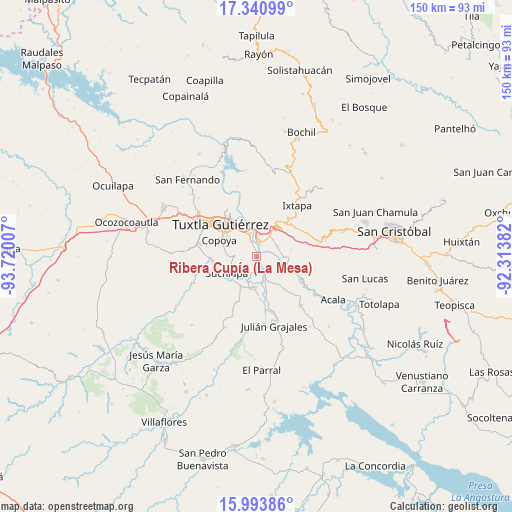
Ribera Cupía (La Mesa) GPS coordinates[2]
16° 40' 6.996" North, 93° 1' 0.984" West
| Map corner | latitude | longitude |
|---|---|---|
| Upper-left | 17.34099°, | -93.72007° |
| Center: | 16.66861°, | -93.01694° |
| Lower-right: | 15.99386°, | -92.31382° |
| Map W x H: | 149.8×149.8 km | = 93.1×93.1mi |
| max Lat: | 32.7° ⇑93.1% North |
| Ribera Cupía (La Mesa): | 16.66861° |
| min Lat: | ⇓6.9% South 14.53588° |
| min Long | Ribera Cupía ( | max Long |
| -117.105° | -93.01694° | -86.73105° |
| W 88.4%⇐ | ⇒11.6% E |
Elevation
Elevation of Ribera Cupía (La Mesa) is 406 m = 1332 ft, and this is 847.7 m = 2781 ft below average elevation for this country.
| Max E: |
3497 m = 11473 ft | 70.2% |
| Avg. | 1253.7 m = 4113 ft | |
| Ribera Cupía (La Mesa) | 406 m = 1332 ft | |
Min E: |
-1 m = -3 ft | 29.8% |
See also: Mexico elevation on elevation.city.
Geographical zone
Ribera Cupía (La Mesa) is located in North Torrid zone (between Equator and Tropic of Cancer). Distance of this Northern Tropic circle is 752.5 km =467.6 mi to North.| Distance of | km | miles | from Ribera Cupía (La Mesa) |
|---|---|---|---|
| North Pole | 8153.7 | 5066.5 | to North |
| Arctic Circle | 5547.8 | 3447.2 | to North |
| Tropic Cancer | 752.5 | 467.6 | to North |
| Equator | 1853.4 | 1151.6 | to South |


Nearby cities:
15 places around Ribera Cupía (La Mesa): (largest is in red/bold)
• Amatal
4.1 km =2.5 mi,  148°
148°
• América Libre
6.6 km =4.1 mi,  155°
155°
• Chiapa de Corzo
4.4 km =2.7 mi,  7°
7°
• Cupasmí
1.2 km =0.7 mi,  63°
63°
• Distrito Federal
8.8 km =5.5 mi,  186°
186°
• Galecio Narcia
8.9 km =5.5 mi,  182°
182°
• General Emiliano Zapata Dos
7.3 km =4.5 mi,  93°
93°
• Jardínes del Grijalva
6.9 km =4.3 mi,  344°
344°
• Juan del Grijalva
7.8 km =4.8 mi,  32°
32°
• Las Flechas
3.7 km =2.3 mi, 344°
• Nueva Palestina (Nandayacuti)
4.7 km =2.9 mi,  98°
98°
• Nuevo Carmen Tonapac
7.2 km =4.5 mi, 64°
• Ribera de Monte Rico (Nacamucuyi)
3 km =1.9 mi,  66°
66°
• Ribera la Unión (Castaño)
7.8 km =4.8 mi, 162°
• Salvador Urbina
4 km =2.5 mi, 157°
Sources, notices
• [Note1] Compared only with cities in Mexico existing in our database
• [Src1] Map data: © OpenStreetMap contributors (CC-BY-SA)
• [Src2] Other city data from geonames.org with taken over terms of usage.
• [Src3] Geographical zone / Annual Mean Temperature by Robert A. Rohde @ Wikipedia
