Galecio Narcia geodata
Galecio Narcia (Chiapas) is a populated place; located in Mexico in America/Mexico_City (GMT-6) time zone. With population of 1,553 people, there are 5553 cities with bigger population in this country. Compared to other cities in Mexico, 93.7% of cities are located further ↑North; 88.4% of cities are located further ←West and 69.4% of cities have higher elevation than Galecio Narcia. Note1


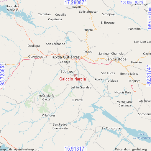
Galecio Narcia GPS coordinates[2]
16° 35' 17.52" North, 93° 1' 13.872" West
| Map corner | latitude | longitude |
|---|---|---|
| Upper-left | 17.26087°, | -93.72365° |
| Center: | 16.5882°, | -93.02052° |
| Lower-right: | 15.91317°, | -92.3174° |
| Map W x H: | 149.9×149.9 km | = 93.1×93.1mi |
| max Lat: | 32.7° ⇑93.7% North |
| Galecio Narcia: | 16.5882° |
| min Lat: | ⇓6.3% South 14.53588° |
| min Long | Galecio Narcia | max Long |
| -117.105° | -93.02052° | -86.73105° |
| W 88.4%⇐ | ⇒11.6% E |
Elevation
Elevation of Galecio Narcia is 448 m = 1470 ft, and this is 805.7 m = 2643 ft below average elevation for this country.
| Max E: |
3497 m = 11473 ft | 69.4% |
| Avg. | 1253.7 m = 4113 ft | |
| Galecio Narcia | 448 m = 1470 ft | |
Min E: |
-1 m = -3 ft | 30.6% |
See also: Mexico elevation on elevation.city.
Geographical zone
Galecio Narcia is located in North Torrid zone (between Equator and Tropic of Cancer). Distance of this Northern Tropic circle is 761.5 km =473.2 mi to North.| Distance of | km | miles | from Galecio Narcia |
|---|---|---|---|
| North Pole | 8162.6 | 5072 | to North |
| Arctic Circle | 5556.7 | 3452.8 | to North |
| Tropic Cancer | 761.5 | 473.2 | to North |
| Equator | 1844.4 | 1146.1 | to South |


Nearby cities:
15 places around Galecio Narcia: (largest is in red/bold)
• Amatal
6 km =3.7 mi,  25°
25°
• América Libre
4.2 km =2.6 mi,  46°
46°
• Cupasmí
9.6 km =6 mi,  8°
8°
• Distrito Federal
0.7 km =0.4 mi,  286°
286°
• Francisco Sarabia
3.9 km =2.4 mi,  155°
155°
• General Emiliano Zapata Dos
11.4 km =7.1 mi,  41°
41°
• Ignacio Allende
7.6 km =4.7 mi, 156°
• Narciso Mendoza
3.5 km =2.2 mi,  105°
105°
• Nicolás Bravo
9.1 km =5.7 mi, 160°
• Nueva Palestina (Nandayacuti)
9.7 km =6 mi, 31°
• Ribera Cupía (La Mesa)
8.9 km =5.5 mi,  2°
2°
• Ribera de Monte Rico (Nacamucuyi)
10.6 km =6.6 mi,  17°
17°
• Ribera la Unión (Castaño)
3.1 km =1.9 mi,  62°
62°
• Salvador Urbina
5.6 km =3.5 mi, 20°
• Suchiapa
9.5 km =5.9 mi,  295°
295°
Sources, notices
• [Note1] Compared only with cities in Mexico existing in our database
• [Src1] Map data: © OpenStreetMap contributors (CC-BY-SA)
• [Src2] Other city data from geonames.org with taken over terms of usage.
• [Src3] Geographical zone / Annual Mean Temperature by Robert A. Rohde @ Wikipedia
