Charco Largo geodata
Charco Largo (Guanajuato) is a populated place; located in Mexico in America/Mexico_City (GMT-6) time zone. With population of 759 people, there are 11537 cities with bigger population in this country. Compared to other cities in Mexico, 62.9% of cities are located further ↓South; 72% of cities are located further →East and 62% of cities have lower elevation than Charco Largo. Note1


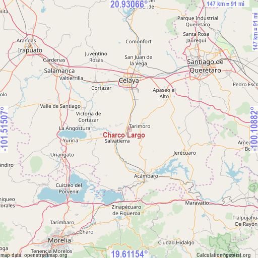
Charco Largo GPS coordinates[2]
20° 16' 21" North, 100° 48' 42.984" West
| Map corner | latitude | longitude |
|---|---|---|
| Upper-left | 20.93066°, | -101.51507° |
| Center: | 20.2725°, | -100.81194° |
| Lower-right: | 19.61154°, | -100.10882° |
| Map W x H: | 146.7×146.7 km | = 91.2×91.2mi |
| max Lat: | 32.7° ⇑37.1% North |
| Charco Largo: | 20.2725° |
| min Lat: | ⇓62.9% South 14.53588° |
| min Long | Charco Largo | max Long |
| -117.105° | -100.81194° | -86.73105° |
| W 28%⇐ | ⇒72% E |
Elevation
Elevation of Charco Largo is 1759 m = 5771 ft, and this is 505.3 m = 1658 ft above average elevation for this country.
| Max E: |
3497 m = 11473 ft | 38% |
| Charco Largo | 1759 m 5771 ft | |
| Avg. | 1253.7 m = 4113 ft | |
Min E: |
-1 m = -3 ft | 62% |
See also: Mexico elevation on elevation.city.
Geographical zone
Charco Largo is located in North Torrid zone (between Equator and Tropic of Cancer). Distance of this Northern Tropic circle is 351.8 km =218.6 mi to North.| Distance of | km | miles | from Charco Largo |
|---|---|---|---|
| North Pole | 7753 | 4817.5 | to North |
| Arctic Circle | 5147.1 | 3198.3 | to North |
| Tropic Cancer | 351.8 | 218.6 | to North |
| Equator | 2254.1 | 1400.6 | to South |


Nearby cities:
15 places around Charco Largo: (largest is in red/bold)
• El Salvador (Ranchito San José del Carmen)
7 km =4.3 mi,  283°
283°
• Galerade Panales
2.5 km =1.6 mi,  353°
353°
• La Calera
4.7 km =2.9 mi,  313°
313°
• La Estancia de San José del Carmen
5.7 km =3.5 mi,  296°
296°
• La Moncada
1.4 km =0.9 mi,  30°
30°
• La Noria de Gallegos
7.6 km =4.7 mi,  21°
21°
• Ojo de Agua de Ballesteros
5.1 km =3.2 mi,  194°
194°
• Panales Jamaica (Cañones)
2.8 km =1.7 mi,  335°
335°
• Providencia de Cacalote
8.4 km =5.2 mi, 15°
• San Isidro
7.9 km =4.9 mi,  285°
285°
• San José del Carmen
8.4 km =5.2 mi,  271°
271°
• San Juan Bautista Cacalote
8.8 km =5.5 mi, 16°
• San Nicolás de la Condesa
5.5 km =3.4 mi,  144°
144°
• Tarimoro
6.1 km =3.8 mi,  78°
78°
• Urireo
7.3 km =4.5 mi,  205°
205°
Sources, notices
• [Note1] Compared only with cities in Mexico existing in our database
• [Src1] Map data: © OpenStreetMap contributors (CC-BY-SA)
• [Src2] Other city data from geonames.org with taken over terms of usage.
• [Src3] Geographical zone / Annual Mean Temperature by Robert A. Rohde @ Wikipedia
