La Paz Tlaxcolpan geodata
La Paz Tlaxcolpan (Puebla) is a populated place; located in Mexico in America/Mexico_City (GMT-6) time zone. With population of 745 people, there are 11760 cities with bigger population in this country. Compared to other cities in Mexico, 66.9% of cities are located further ↑North; 60.9% of cities are located further ←West and 78.3% of cities have lower elevation than La Paz Tlaxcolpan. Note1


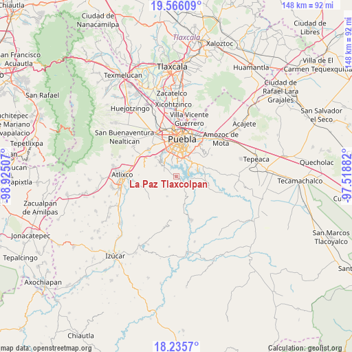
La Paz Tlaxcolpan GPS coordinates[2]
18° 54' 7.992" North, 98° 13' 18.984" West
| Map corner | latitude | longitude |
|---|---|---|
| Upper-left | 19.56609°, | -98.92507° |
| Center: | 18.90222°, | -98.22194° |
| Lower-right: | 18.2357°, | -97.51882° |
| Map W x H: | 147.9×147.9 km | = 91.9×91.9mi |
| max Lat: | 32.7° ⇑66.9% North |
| La Paz Tlaxcolpan: | 18.90222° |
| min Lat: | ⇓33.1% South 14.53588° |
| min Long | La Paz Tlaxcolp | max Long |
| -117.105° | -98.22194° | -86.73105° |
| W 60.9%⇐ | ⇒39.1% E |
Elevation
Elevation of La Paz Tlaxcolpan is 2094 m = 6870 ft, and this is 840.3 m = 2757 ft above average elevation for this country.
| Max E: |
3497 m = 11473 ft | 21.7% |
| La Paz Tlaxcolpan | 2094 m 6870 ft | |
| Avg. | 1253.7 m = 4113 ft | |
Min E: |
-1 m = -3 ft | 78.3% |
See also: Mexico elevation on elevation.city.
Geographical zone
La Paz Tlaxcolpan is located in North Torrid zone (between Equator and Tropic of Cancer). Distance of this Northern Tropic circle is 504.2 km =313.3 mi to North.| Distance of | km | miles | from La Paz Tlaxcolpan |
|---|---|---|---|
| North Pole | 7905.3 | 4912.1 | to North |
| Arctic Circle | 5299.4 | 3292.9 | to North |
| Tropic Cancer | 504.2 | 313.3 | to North |
| Equator | 2101.7 | 1305.9 | to South |


Nearby cities:
15 places around La Paz Tlaxcolpan: (largest is in red/bold)
• 18 de Marzo
9.8 km =6.1 mi,  41°
41°
• Buenavista Tetela
5.2 km =3.2 mi,  67°
67°
• El Capulo (La Quebradora)
7.2 km =4.5 mi,  316°
316°
• Guadalupe
9.3 km =5.8 mi,  48°
48°
• Los Ángeles Tetela
5.9 km =3.7 mi,  103°
103°
• Resurgimiento Atotonilco
5.8 km =3.6 mi,  17°
17°
• San Andrés Azumiatla
3.3 km =2.1 mi,  273°
273°
• San Antonio Arenillas
7.1 km =4.4 mi, 41°
• San José Texaluca
9.5 km =5.9 mi,  93°
93°
• San José Xacxamayo
7.4 km =4.6 mi,  127°
127°
• San José Zetina
5.8 km =3.6 mi,  291°
291°
• San José el Rincón
3 km =1.9 mi, 127°
• San Pedro Zacachimalpa
8.3 km =5.2 mi,  56°
56°
• Santa María Guadalupe Tecola
2.8 km =1.7 mi,  80°
80°
• Santa María Malacatepec
9.5 km =5.9 mi,  297°
297°
Sources, notices
• [Note1] Compared only with cities in Mexico existing in our database
• [Src1] Map data: © OpenStreetMap contributors (CC-BY-SA)
• [Src2] Other city data from geonames.org with taken over terms of usage.
• [Src3] Geographical zone / Annual Mean Temperature by Robert A. Rohde @ Wikipedia
