La Esperanza geodata
La Esperanza (Morelos) is a populated place; located in Mexico in America/Mexico_City (GMT-6) time zone. With population of 725 people, there are 12042 cities with bigger population in this country. Compared to other cities in Mexico, 68.6% of cities are located further ↑North; 53.3% of cities are located further →East and 53.9% of cities have higher elevation than La Esperanza. Note1


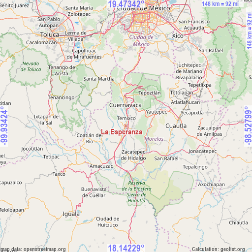
La Esperanza GPS coordinates[2]
18° 48' 33.012" North, 99° 13' 51.996" West
| Map corner | latitude | longitude |
|---|---|---|
| Upper-left | 19.47342°, | -99.93424° |
| Center: | 18.80917°, | -99.23111° |
| Lower-right: | 18.14229°, | -98.52799° |
| Map W x H: | 148×148 km | = 92×92mi |
| max Lat: | 32.7° ⇑68.6% North |
| La Esperanza: | 18.80917° |
| min Lat: | ⇓31.4% South 14.53588° |
| min Long | La Esperanza | max Long |
| -117.105° | -99.23111° | -86.73105° |
| W 46.7%⇐ | ⇒53.3% E |
Elevation
Elevation of La Esperanza is 1250 m = 4101 ft, and this is 3.7 m = 12 ft below average elevation for this country.
| Max E: |
3497 m = 11473 ft | 53.9% |
| Avg. | 1253.7 m = 4113 ft | |
| La Esperanza | 1250 m = 4101 ft | |
Min E: |
-1 m = -3 ft | 46.1% |
See also: Mexico elevation on elevation.city.
Geographical zone
La Esperanza is located in North Torrid zone (between Equator and Tropic of Cancer). Distance of this Northern Tropic circle is 514.5 km =319.7 mi to North.| Distance of | km | miles | from La Esperanza |
|---|---|---|---|
| North Pole | 7915.7 | 4918.6 | to North |
| Arctic Circle | 5309.8 | 3299.4 | to North |
| Tropic Cancer | 514.5 | 319.7 | to North |
| Equator | 2091.4 | 1299.5 | to South |


Nearby cities:
15 places around La Esperanza: (largest is in red/bold)
• Benito Juárez (La Monera)
3.9 km =2.4 mi,  276°
276°
• Campo Sotelo
3.3 km =2.1 mi,  34°
34°
• Chiconcuac
3.9 km =2.4 mi,  139°
139°
• Emiliano Zapata
6 km =3.7 mi,  54°
54°
• Eterna Primavera
4.8 km =3 mi,  323°
323°
• Francisco Villa
2.8 km =1.7 mi,  210°
210°
• Ninguno [Centro de Readaptación Social de Atlacholoaya]
5.7 km =3.5 mi,  178°
178°
• Solidaridad
6.1 km =3.8 mi, 322°
• Temixco
4.9 km =3 mi,  7°
7°
• Tepetzingo
6.2 km =3.9 mi,  115°
115°
• Tetecalita
7.3 km =4.5 mi,  128°
128°
• Tezoyuca
3.1 km =1.9 mi,  98°
98°
• Tres de Mayo
7 km =4.3 mi,  19°
19°
• Unidad Habitacional José María Morelos y Pavón
3.5 km =2.2 mi,  290°
290°
• Xochitepec
3.2 km =2 mi, 178°
Sources, notices
• [Note1] Compared only with cities in Mexico existing in our database
• [Src1] Map data: © OpenStreetMap contributors (CC-BY-SA)
• [Src2] Other city data from geonames.org with taken over terms of usage.
• [Src3] Geographical zone / Annual Mean Temperature by Robert A. Rohde @ Wikipedia
