Vicente Guerrero geodata
Vicente Guerrero (Puebla) is a populated place; located in Mexico in America/Mexico_City (GMT-6) time zone. With population of 722 people, there are 12092 cities with bigger population in this country. Compared to other cities in Mexico, 59.6% of cities are located further ↑North; 72.1% of cities are located further ←West and 97.3% of cities have lower elevation than Vicente Guerrero. Note1


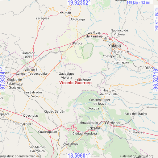
Vicente Guerrero GPS coordinates[2]
19° 15' 39.996" North, 97° 13' 49.008" West
| Map corner | latitude | longitude |
|---|---|---|
| Upper-left | 19.92352°, | -97.93341° |
| Center: | 19.26111°, | -97.23028° |
| Lower-right: | 18.59601°, | -96.52716° |
| Map W x H: | 147.6×147.6 km | = 91.7×91.7mi |
| max Lat: | 32.7° ⇑59.6% North |
| Vicente Guerrero: | 19.26111° |
| min Lat: | ⇓40.4% South 14.53588° |
| min Long | Vicente Guerrer | max Long |
| -117.105° | -97.23028° | -86.73105° |
| W 72.1%⇐ | ⇒27.9% E |
Elevation
Elevation of Vicente Guerrero is 2700 m = 8858 ft, and this is 1446.3 m = 4745 ft above average elevation for this country.
| Max E: |
3497 m = 11473 ft | 2.7% |
| Vicente Guerrero | 2700 m 8858 ft | |
| Avg. | 1253.7 m = 4113 ft | |
Min E: |
-1 m = -3 ft | 97.3% |
See also: Mexico elevation on elevation.city.
Geographical zone
Vicente Guerrero is located in North Torrid zone (between Equator and Tropic of Cancer). Distance of this Northern Tropic circle is 464.3 km =288.5 mi to North.| Distance of | km | miles | from Vicente Guerrero |
|---|---|---|---|
| North Pole | 7865.4 | 4887.3 | to North |
| Arctic Circle | 5259.5 | 3268.1 | to North |
| Tropic Cancer | 464.3 | 288.5 | to North |
| Equator | 2141.6 | 1330.7 | to South |


Nearby cities:
15 places around Vicente Guerrero: (largest is in red/bold)
• Acocomotla
2.3 km =1.4 mi,  36°
36°
• Ahuacapan
10 km =6.2 mi,  78°
78°
• El Carmen
3.7 km =2.3 mi,  125°
125°
• El Triunfo
7.3 km =4.5 mi,  121°
121°
• Francisco I. Madero
1.3 km =0.8 mi,  162°
162°
• González Ortega
10 km =6.2 mi,  335°
335°
• Ignacio Zaragoza
3.8 km =2.4 mi,  58°
58°
• La Providencia
6 km =3.7 mi,  27°
27°
• La Trinidad
3.3 km =2.1 mi, 32°
• Pocitos
5.7 km =3.5 mi,  277°
277°
• Rafael J. García
5 km =3.1 mi,  98°
98°
• Saltillo
8 km =5 mi,  299°
299°
• San Antonio
4.7 km =2.9 mi, 77°
• San José Manzanitos
1.6 km =1 mi,  90°
90°
• Tlanalapan
4.9 km =3 mi,  256°
256°
Sources, notices
• [Note1] Compared only with cities in Mexico existing in our database
• [Src1] Map data: © OpenStreetMap contributors (CC-BY-SA)
• [Src2] Other city data from geonames.org with taken over terms of usage.
• [Src3] Geographical zone / Annual Mean Temperature by Robert A. Rohde @ Wikipedia
