San Eligio geodata
San Eligio (Tabasco) is a populated place; located in Mexico in America/Mexico_City (GMT-6) time zone. With population of 681 people, there are 12756 cities with bigger population in this country. Compared to other cities in Mexico, 79% of cities are located further ↑North; 88% of cities are located further ←West and 94.6% of cities have higher elevation than San Eligio. Note1


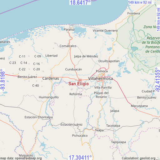
San Eligio GPS coordinates[2]
17° 58' 27.012" North, 93° 7' 0.012" West
| Map corner | latitude | longitude |
|---|---|---|
| Upper-left | 18.6417°, | -93.8198° |
| Center: | 17.97417°, | -93.11667° |
| Lower-right: | 17.30411°, | -92.41355° |
| Map W x H: | 148.7×148.7 km | = 92.4×92.4mi |
| max Lat: | 32.7° ⇑79% North |
| San Eligio: | 17.97417° |
| min Lat: | ⇓21% South 14.53588° |
| min Long | San Eligio | max Long |
| -117.105° | -93.11667° | -86.73105° |
| W 88%⇐ | ⇒12% E |
Elevation
Elevation of San Eligio is 14 m = 46 ft, and this is 1239.7 m = 4067 ft below average elevation for this country.
| Max E: |
3497 m = 11473 ft | 94.6% |
| Avg. | 1253.7 m = 4113 ft | |
| San Eligio | 14 m = 46 ft | |
Min E: |
-1 m = -3 ft | 5.4% |
See also: Mexico elevation on elevation.city.
Geographical zone
San Eligio is located in North Torrid zone (between Equator and Tropic of Cancer). Distance of this Northern Tropic circle is 607.4 km =377.4 mi to North.| Distance of | km | miles | from San Eligio |
|---|---|---|---|
| North Pole | 8008.5 | 4976.2 | to North |
| Arctic Circle | 5402.6 | 3357 | to North |
| Tropic Cancer | 607.4 | 377.4 | to North |
| Equator | 1998.5 | 1241.8 | to South |


Nearby cities:
15 places around San Eligio: (largest is in red/bold)
• Adolfo Ruiz Cortines (Morelitos)
9.3 km =5.8 mi,  320°
320°
• Anacleto Canabal 2da. Sección
9.8 km =6.1 mi,  89°
89°
• Ceiba 1ra. Sección (Jahuactal)
9.8 km =6.1 mi,  2°
2°
• Cumuapa 1ra. Sección
2.6 km =1.6 mi,  298°
298°
• Cunduacán
11.8 km =7.3 mi,  329°
329°
• Dos Ceibas
11.4 km =7.1 mi,  49°
49°
• El Carmen (El Limón)
10.6 km =6.6 mi,  208°
208°
• González 1ra. Sección (Punta Brava)
9.3 km =5.8 mi, 87°
• Gregorio Méndez
8.8 km =5.5 mi,  22°
22°
• Marín
8.1 km =5 mi,  287°
287°
• Marín (Rampa de Panuncio)
9.5 km =5.9 mi,  279°
279°
• Miguel Hidalgo
7.5 km =4.7 mi,  180°
180°
• Rancho Nuevo
11.8 km =7.3 mi, 23°
• San Miguel 2da. Sección
9.6 km =6 mi,  218°
218°
• Vicente Guerrero
10 km =6.2 mi,  193°
193°
Sources, notices
• [Note1] Compared only with cities in Mexico existing in our database
• [Src1] Map data: © OpenStreetMap contributors (CC-BY-SA)
• [Src2] Other city data from geonames.org with taken over terms of usage.
• [Src3] Geographical zone / Annual Mean Temperature by Robert A. Rohde @ Wikipedia
