Vicente Guerrero geodata
Vicente Guerrero (Chiapas) is a populated place; located in Mexico in America/Mexico_City (GMT-6) time zone. With population of 596 people, there are 14429 cities with bigger population in this country. Compared to other cities in Mexico, 79.8% of cities are located further ↑North; 87.9% of cities are located further ←West and 94.6% of cities have higher elevation than Vicente Guerrero. Note1


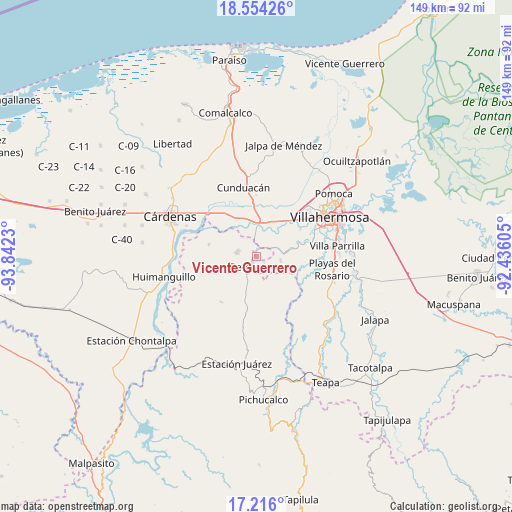
Vicente Guerrero GPS coordinates[2]
17° 53' 11.004" North, 93° 8' 21.012" West
| Map corner | latitude | longitude |
|---|---|---|
| Upper-left | 18.55426°, | -93.8423° |
| Center: | 17.88639°, | -93.13917° |
| Lower-right: | 17.216°, | -92.43605° |
| Map W x H: | 148.8×148.8 km | = 92.5×92.5mi |
| max Lat: | 32.7° ⇑79.8% North |
| Vicente Guerrero: | 17.88639° |
| min Lat: | ⇓20.2% South 14.53588° |
| min Long | Vicente Guerrer | max Long |
| -117.105° | -93.13917° | -86.73105° |
| W 87.9%⇐ | ⇒12.1% E |
Elevation
Elevation of Vicente Guerrero is 14 m = 46 ft, and this is 1239.7 m = 4067 ft below average elevation for this country.
| Max E: |
3497 m = 11473 ft | 94.6% |
| Avg. | 1253.7 m = 4113 ft | |
| Vicente Guerrero | 14 m = 46 ft | |
Min E: |
-1 m = -3 ft | 5.4% |
See also: Mexico elevation on elevation.city.
Geographical zone
Vicente Guerrero is located in North Torrid zone (between Equator and Tropic of Cancer). Distance of this Northern Tropic circle is 617.1 km =383.4 mi to North.| Distance of | km | miles | from Vicente Guerrero |
|---|---|---|---|
| North Pole | 8018.3 | 4982.3 | to North |
| Arctic Circle | 5412.4 | 3363.1 | to North |
| Tropic Cancer | 617.1 | 383.4 | to North |
| Equator | 1988.8 | 1235.8 | to South |


Nearby cities:
15 places around Vicente Guerrero: (largest is in red/bold)
• Cumuapa 1ra. Sección
11 km =6.8 mi,  0°
0°
• El Carmen (El Limón)
2.8 km =1.7 mi,  279°
279°
• González 1ra. Sección (Punta Brava)
15.5 km =9.6 mi,  49°
49°
• Luis Gil Pérez
7.3 km =4.5 mi,  99°
99°
• Marín
13.3 km =8.3 mi,  336°
336°
• Marín (Rampa de Panuncio)
13.3 km =8.3 mi,  328°
328°
• Miguel Hidalgo
3.2 km =2 mi, 45°
• Nuevo Volcán Chichonal
13 km =8.1 mi,  166°
166°
• Pablo L. Sidar
11.7 km =7.3 mi,  82°
82°
• Rafael Pascacio Gamboa
14.1 km =8.8 mi, 284°
• Reforma
2.6 km =1.6 mi,  203°
203°
• San Eligio
10 km =6.2 mi,  13°
13°
• San Miguel 2da. Sección
4.2 km =2.6 mi,  301°
301°
• Santa Cruz
9 km =5.6 mi, 196°
• Santa Cruz Tepate Abajo
14.5 km =9 mi,  131°
131°
Sources, notices
• [Note1] Compared only with cities in Mexico existing in our database
• [Src1] Map data: © OpenStreetMap contributors (CC-BY-SA)
• [Src2] Other city data from geonames.org with taken over terms of usage.
• [Src3] Geographical zone / Annual Mean Temperature by Robert A. Rohde @ Wikipedia
