San Pablo Potrerillos geodata
San Pablo Potrerillos (Querétaro) is a populated place; located in Mexico in America/Mexico_City (GMT-6) time zone. With population of 679 people, there are 12793 cities with bigger population in this country. Compared to other cities in Mexico, 63.7% of cities are located further ↓South; 64.9% of cities are located further →East and 82.9% of cities have lower elevation than San Pablo Potrerillos. Note1


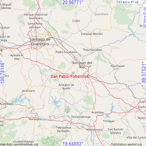
San Pablo Potrerillos GPS coordinates[2]
20° 18' 34.992" North, 100° 4' 41.988" West
| Map corner | latitude | longitude |
|---|---|---|
| Upper-left | 20.96771°, | -100.78146° |
| Center: | 20.30972°, | -100.07833° |
| Lower-right: | 19.64892°, | -99.37521° |
| Map W x H: | 146.6×146.6 km | = 91.1×91.1mi |
| max Lat: | 32.7° ⇑36.3% North |
| San Pablo Potrerillos: | 20.30972° |
| min Lat: | ⇓63.7% South 14.53588° |
| min Long | San Pablo Potre | max Long |
| -117.105° | -100.07833° | -86.73105° |
| W 35.1%⇐ | ⇒64.9% E |
Elevation
Elevation of San Pablo Potrerillos is 2212 m = 7257 ft, and this is 958.3 m = 3144 ft above average elevation for this country.
| Max E: |
3497 m = 11473 ft | 17.1% |
| San Pablo Potrerillos | 2212 m 7257 ft | |
| Avg. | 1253.7 m = 4113 ft | |
Min E: |
-1 m = -3 ft | 82.9% |
See also: Mexico elevation on elevation.city.
Geographical zone
San Pablo Potrerillos is located in North Torrid zone (between Equator and Tropic of Cancer). Distance of this Northern Tropic circle is 347.7 km =216.1 mi to North.| Distance of | km | miles | from San Pablo Potrerillos |
|---|---|---|---|
| North Pole | 7748.8 | 4814.9 | to North |
| Arctic Circle | 5142.9 | 3195.6 | to North |
| Tropic Cancer | 347.7 | 216.1 | to North |
| Equator | 2258.2 | 1403.2 | to South |


Nearby cities:
15 places around San Pablo Potrerillos: (largest is in red/bold)
• Buenavista
5.7 km =3.5 mi,  67°
67°
• Casa Blanca
10.5 km =6.5 mi,  35°
35°
• Dolores Cuadrilla de Enmedio
4.8 km =3 mi,  358°
358°
• El Jazmín
5.1 km =3.2 mi, 40°
• El Rosario
9.2 km =5.7 mi,  8°
8°
• Galindo
10 km =6.2 mi,  347°
347°
• Hacienda Blanca
4.9 km =3 mi,  209°
209°
• Laguna de Vaquerías
7.7 km =4.8 mi,  309°
309°
• Ojo de Agua
6.1 km =3.8 mi,  46°
46°
• Puerta de Alegrías
5.4 km =3.4 mi,  329°
329°
• Sabino Chicho
6.6 km =4.1 mi,  61°
61°
• San Martín
10.9 km =6.8 mi,  236°
236°
• Santa Lucía
2.3 km =1.4 mi, 72°
• Vaquerías
6.8 km =4.2 mi,  321°
321°
• Vista Hermosa (Cuasinada)
9.5 km =5.9 mi, 46°
Sources, notices
• [Note1] Compared only with cities in Mexico existing in our database
• [Src1] Map data: © OpenStreetMap contributors (CC-BY-SA)
• [Src2] Other city data from geonames.org with taken over terms of usage.
• [Src3] Geographical zone / Annual Mean Temperature by Robert A. Rohde @ Wikipedia
