Galindo geodata
Galindo (Querétaro) is a populated place; located in Mexico in America/Mexico_City (GMT-6) time zone. With population of 3,079 people, there are 2929 cities with bigger population in this country. Compared to other cities in Mexico, 65.6% of cities are located further ↓South; 65.1% of cities are located further →East and 71.1% of cities have lower elevation than Galindo. Note1


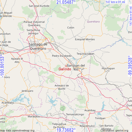
Galindo GPS coordinates[2]
20° 23' 50.1" North, 100° 5' 54.24" West
| Map corner | latitude | longitude |
|---|---|---|
| Upper-left | 21.05487°, | -100.80153° |
| Center: | 20.39725°, | -100.0984° |
| Lower-right: | 19.73682°, | -99.39528° |
| Map W x H: | 146.6×146.6 km | = 91.1×91.1mi |
| max Lat: | 32.7° ⇑34.4% North |
| Galindo: | 20.39725° |
| min Lat: | ⇓65.6% South 14.53588° |
| min Long | Galindo | max Long |
| -117.105° | -100.0984° | -86.73105° |
| W 34.9%⇐ | ⇒65.1% E |
Elevation
Elevation of Galindo is 1948 m = 6391 ft, and this is 694.3 m = 2278 ft above average elevation for this country.
| Max E: |
3497 m = 11473 ft | 28.9% |
| Galindo | 1948 m 6391 ft | |
| Avg. | 1253.7 m = 4113 ft | |
Min E: |
-1 m = -3 ft | 71.1% |
See also: Mexico elevation on elevation.city.
Geographical zone
Galindo is located in North Torrid zone (between Equator and Tropic of Cancer). Distance of this Northern Tropic circle is 338 km =210 mi to North.| Distance of | km | miles | from Galindo |
|---|---|---|---|
| North Pole | 7739.1 | 4808.9 | to North |
| Arctic Circle | 5133.2 | 3189.6 | to North |
| Tropic Cancer | 338 | 210 | to North |
| Equator | 2268 | 1409.3 | to South |


Nearby cities:
15 places around Galindo: (largest is in red/bold)
• Arcila
1.9 km =1.2 mi,  320°
320°
• Casa Blanca
8.2 km =5.1 mi,  98°
98°
• Dolores Cuadrilla de Enmedio
5.3 km =3.3 mi,  158°
158°
• El Coto
3.8 km =2.4 mi,  266°
266°
• El Jazmín
8 km =5 mi,  137°
137°
• El Rosario
3.4 km =2.1 mi, 100°
• La D
7.4 km =4.6 mi,  310°
310°
• La Estancia
4.3 km =2.7 mi,  51°
51°
• Laguna de Vaquerías
6.2 km =3.9 mi,  218°
218°
• Loma Linda
7 km =4.3 mi,  86°
86°
• Puerta de Alegrías
5.1 km =3.2 mi,  187°
187°
• San Antonio la D
7.3 km =4.5 mi,  291°
291°
• San Germán
8.1 km =5 mi,  32°
32°
• San Javier
7.4 km =4.6 mi, 30°
• Vaquerías
4.9 km =3 mi,  206°
206°
Sources, notices
• [Note1] Compared only with cities in Mexico existing in our database
• [Src1] Map data: © OpenStreetMap contributors (CC-BY-SA)
• [Src2] Other city data from geonames.org with taken over terms of usage.
• [Src3] Geographical zone / Annual Mean Temperature by Robert A. Rohde @ Wikipedia
