Campeche geodata
Campeche (Chiapas) is a populated place; located in Mexico in America/Mexico_City (GMT-6) time zone. With population of 676 people, there are 12846 cities with bigger population in this country. Compared to other cities in Mexico, 86.8% of cities are located further ↑North; 87.2% of cities are located further ←West and 66% of cities have higher elevation than Campeche. Note1


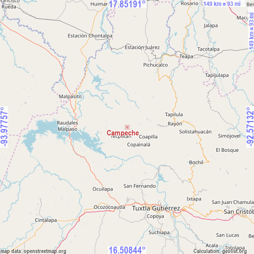
Campeche GPS coordinates[2]
17° 10' 53.004" North, 93° 16' 27.984" West
| Map corner | latitude | longitude |
|---|---|---|
| Upper-left | 17.85191°, | -93.97757° |
| Center: | 17.18139°, | -93.27444° |
| Lower-right: | 16.50844°, | -92.57132° |
| Map W x H: | 149.4×149.4 km | = 92.8×92.8mi |
| max Lat: | 32.7° ⇑86.8% North |
| Campeche: | 17.18139° |
| min Lat: | ⇓13.2% South 14.53588° |
| min Long | Campeche | max Long |
| -117.105° | -93.27444° | -86.73105° |
| W 87.2%⇐ | ⇒12.8% E |
Elevation
Elevation of Campeche is 635 m = 2083 ft, and this is 618.7 m = 2030 ft below average elevation for this country.
| Max E: |
3497 m = 11473 ft | 66% |
| Avg. | 1253.7 m = 4113 ft | |
| Campeche | 635 m = 2083 ft | |
Min E: |
-1 m = -3 ft | 34% |
See also: Mexico elevation on elevation.city.
Geographical zone
Campeche is located in North Torrid zone (between Equator and Tropic of Cancer). Distance of this Northern Tropic circle is 695.5 km =432.2 mi to North.| Distance of | km | miles | from Campeche |
|---|---|---|---|
| North Pole | 8096.7 | 5031.1 | to North |
| Arctic Circle | 5490.8 | 3411.8 | to North |
| Tropic Cancer | 695.5 | 432.2 | to North |
| Equator | 1910.4 | 1187.1 | to South |


Nearby cities:
15 places around Campeche: (largest is in red/bold)
• Benito Juárez
5.2 km =3.2 mi,  149°
149°
• Copainalá
11.9 km =7.4 mi, 145°
• El Porvenir
12.5 km =7.8 mi,  269°
269°
• Emiliano Zapata
8.3 km =5.2 mi,  299°
299°
• Francisco I. Madero
12.8 km =8 mi,  285°
285°
• Julián Grajales (San Antonio)
6.6 km =4.1 mi,  168°
168°
• Miguel Hidalgo (Zacalapa)
8.7 km =5.4 mi,  129°
129°
• Naranjo
13.1 km =8.1 mi,  25°
25°
• Ocotepec
12.7 km =7.9 mi,  66°
66°
• Rivera el Viejo Carmen
11.6 km =7.2 mi,  0°
0°
• Rosario
10.8 km =6.7 mi,  161°
161°
• San Antonio Poyono
8.6 km =5.3 mi,  63°
63°
• San Pablo Huacano
7.3 km =4.5 mi,  77°
77°
• Tecpatán
6.3 km =3.9 mi,  218°
218°
• Ángel Albino Corzo (Guadalupe)
6.1 km =3.8 mi,  180°
180°
Sources, notices
• [Note1] Compared only with cities in Mexico existing in our database
• [Src1] Map data: © OpenStreetMap contributors (CC-BY-SA)
• [Src2] Other city data from geonames.org with taken over terms of usage.
• [Src3] Geographical zone / Annual Mean Temperature by Robert A. Rohde @ Wikipedia
