Ocotepec geodata
Ocotepec (Chiapas) is a seat of a second-order administrative division; located in Mexico in America/Mexico_City (GMT-6) time zone. With population of 4,663 people, there are 1978 cities with bigger population in this country. Compared to other cities in Mexico, 86.2% of cities are located further ↑North; 87.8% of cities are located further ←West and 50.8% of cities have lower elevation than Ocotepec. Note1


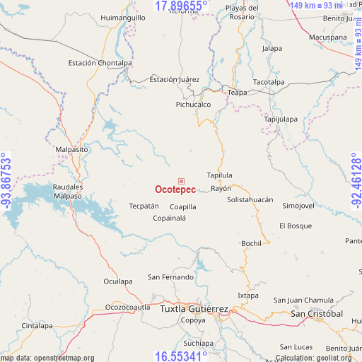
Ocotepec GPS coordinates[2]
17° 13' 34.32" North, 93° 9' 51.84" West
| Map corner | latitude | longitude |
|---|---|---|
| Upper-left | 17.89655°, | -93.86753° |
| Center: | 17.2262°, | -93.1644° |
| Lower-right: | 16.55341°, | -92.46128° |
| Map W x H: | 149.3×149.3 km | = 92.8×92.8mi |
| max Lat: | 32.7° ⇑86.2% North |
| Ocotepec: | 17.2262° |
| min Lat: | ⇓13.8% South 14.53588° |
| min Long | Ocotepec | max Long |
| -117.105° | -93.1644° | -86.73105° |
| W 87.8%⇐ | ⇒12.2% E |
Elevation
Elevation of Ocotepec is 1476 m = 4843 ft, and this is 222.3 m = 729 ft above average elevation for this country.
| Max E: |
3497 m = 11473 ft | 49.2% |
| Ocotepec | 1476 m 4843 ft | |
| Avg. | 1253.7 m = 4113 ft | |
Min E: |
-1 m = -3 ft | 50.8% |
See also: Mexico elevation on elevation.city.
Geographical zone
Ocotepec is located in North Torrid zone (between Equator and Tropic of Cancer). Distance of this Northern Tropic circle is 690.5 km =429.1 mi to North.| Distance of | km | miles | from Ocotepec |
|---|---|---|---|
| North Pole | 8091.7 | 5027.9 | to North |
| Arctic Circle | 5485.8 | 3408.7 | to North |
| Tropic Cancer | 690.5 | 429.1 | to North |
| Equator | 1915.4 | 1190.2 | to South |


Nearby cities:
15 places around Ocotepec: (largest is in red/bold)
• Campeche
12.7 km =7.9 mi,  246°
246°
• Coapilla
10.6 km =6.6 mi,  177°
177°
• El Carrizal
11.7 km =7.3 mi,  127°
127°
• El Triunfo
11.8 km =7.3 mi,  94°
94°
• Guadalupe Victoria
10.7 km =6.6 mi,  1°
1°
• Miguel Hidalgo (Zacalapa)
11.6 km =7.2 mi,  205°
205°
• Naranjo
9.1 km =5.7 mi,  318°
318°
• Pantepec
12.9 km =8 mi,  109°
109°
• San Andrés Carrizal
2.5 km =1.6 mi,  116°
116°
• San Antonio Poyono
4.1 km =2.5 mi, 253°
• San Francisco Ocotal
1.9 km =1.2 mi, 127°
• San Isidro las Banderas
11.1 km =6.9 mi, 87°
• San Pablo Huacano
5.7 km =3.5 mi,  233°
233°
• Tapalapa
7.4 km =4.6 mi, 121°
• Vicente Guerrero
8.6 km =5.3 mi,  326°
326°
Sources, notices
• [Note1] Compared only with cities in Mexico existing in our database
• [Src1] Map data: © OpenStreetMap contributors (CC-BY-SA)
• [Src2] Other city data from geonames.org with taken over terms of usage.
• [Src3] Geographical zone / Annual Mean Temperature by Robert A. Rohde @ Wikipedia
