Allende 1ra. Sección geodata
Allende 1ra. Sección (Chiapas) is a populated place; located in Mexico in America/Mexico_City (GMT-6) time zone. With population of 657 people, there are 13209 cities with bigger population in this country. Compared to other cities in Mexico, 81.2% of cities are located further ↑North; 87% of cities are located further ←West and 83.4% of cities have higher elevation than Allende 1ra. Sección. Note1
Current local time in Allende 1ra. Sección:
08:27 AM, WednesdayDifference from your time zone: hours


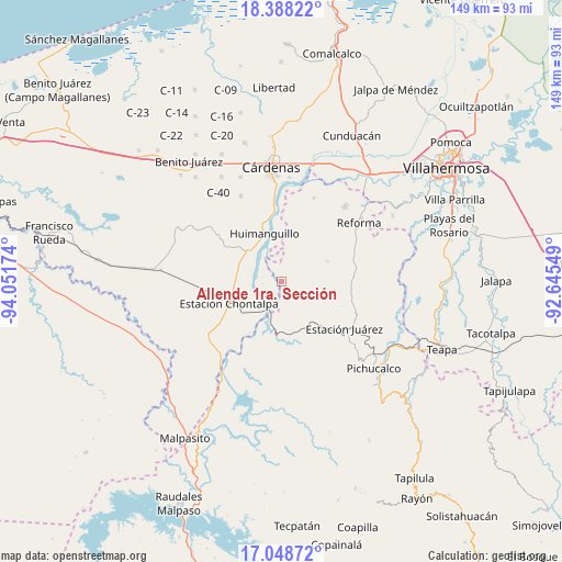
Allende 1ra. Sección GPS coordinates[2]
17° 43' 10.992" North, 93° 20' 54.996" West
| Map corner | latitude | longitude |
|---|---|---|
| Upper-left | 18.38822°, | -94.05174° |
| Center: | 17.71972°, | -93.34861° |
| Lower-right: | 17.04872°, | -92.64549° |
| Map W x H: | 148.9×148.9 km | = 92.5×92.5mi |
| max Lat: | 32.7° ⇑81.2% North |
| Allende 1ra. Sección: | 17.71972° |
| min Lat: | ⇓18.8% South 14.53588° |
| min Long | Allende 1ra. Se | max Long |
| -117.105° | -93.34861° | -86.73105° |
| W 87%⇐ | ⇒13% E |
Elevation
Elevation of Allende 1ra. Sección is 57 m = 187 ft, and this is 1196.7 m = 3926 ft below average elevation for this country.
| Max E: |
3497 m = 11473 ft | 83.4% |
| Avg. | 1253.7 m = 4113 ft | |
| Allende 1ra. Sección | 57 m = 187 ft | |
Min E: |
-1 m = -3 ft | 16.6% |
See also: Mexico elevation on elevation.city.
Geographical zone
Allende 1ra. Sección is located in North Torrid zone (between Equator and Tropic of Cancer). Distance of this Northern Tropic circle is 635.7 km =395 mi to North.| Distance of | km | miles | from Allende 1ra. Sección |
|---|---|---|---|
| North Pole | 8036.8 | 4993.8 | to North |
| Arctic Circle | 5430.9 | 3374.6 | to North |
| Tropic Cancer | 635.7 | 395 | to North |
| Equator | 1970.2 | 1224.2 | to South |


Nearby cities:
15 places around Allende 1ra. Sección: (largest is in red/bold)
• Caobanal 1ra. Sección (Mezcalapa)
9.3 km =5.8 mi,  211°
211°
• Chicoacán
14.9 km =9.3 mi,  288°
288°
• Chicoacán (Ampliación)
11.7 km =7.3 mi, 290°
• Chontalpa
15.3 km =9.5 mi,  247°
247°
• El Paraíso
13.4 km =8.3 mi,  68°
68°
• El Triunfo 1ra. Sección (Cardona)
17.5 km =10.9 mi,  135°
135°
• El Triunfo 2da. Sección
17.6 km =10.9 mi,  150°
150°
• Estación San Manuel
8.4 km =5.2 mi, 206°
• Huapaque 1ra. Sección (Huapacón)
10.1 km =6.3 mi, 72°
• Huimanguillo
13.4 km =8.3 mi,  341°
341°
• La Luz
12.5 km =7.8 mi,  331°
331°
• Libertad
14.6 km =9.1 mi, 329°
• Paredón 3ra. Sección
4.1 km =2.5 mi,  224°
224°
• Platanar Abajo 1ra. Sección (La Crimea)
14.3 km =8.9 mi,  169°
169°
• Plutarco Elías Calles
12.7 km =7.9 mi,  203°
203°
Sources, notices
• [Note1] Compared only with cities in Mexico existing in our database
• [Src1] Map data: © OpenStreetMap contributors (CC-BY-SA)
• [Src2] Other city data from geonames.org with taken over terms of usage.
• [Src3] Geographical zone / Annual Mean Temperature by Robert A. Rohde @ Wikipedia
