Ranchito de Inzunza geodata
Ranchito de Inzunza (Sinaloa) is a populated place; located in Mexico in America/Mazatlan (GMT-7) time zone. With population of 619 people, there are 13941 cities with bigger population in this country. Compared to other cities in Mexico, 93.3% of cities are located further ↓South; 96.3% of cities are located further →East and 90% of cities have higher elevation than Ranchito de Inzunza. Note1


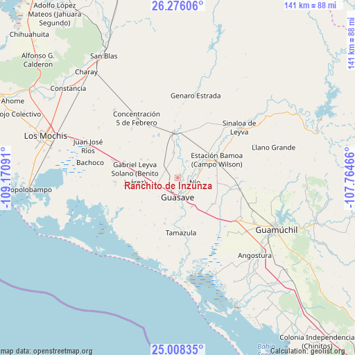
Ranchito de Inzunza GPS coordinates[2]
25° 38' 38.004" North, 108° 28' 4.008" West
| Map corner | latitude | longitude |
|---|---|---|
| Upper-left | 26.27606°, | -109.17091° |
| Center: | 25.64389°, | -108.46778° |
| Lower-right: | 25.00835°, | -107.76466° |
| Map W x H: | 141×141 km | = 87.6×87.6mi |
| max Lat: | 32.7° ⇑6.7% North |
| Ranchito de Inzunza: | 25.64389° |
| min Lat: | ⇓93.3% South 14.53588° |
| min Long | Ranchito de Inz | max Long |
| -117.105° | -108.46778° | -86.73105° |
| W 3.7%⇐ | ⇒96.3% E |
Elevation
Elevation of Ranchito de Inzunza is 24 m = 79 ft, and this is 1229.7 m = 4034 ft below average elevation for this country.
| Max E: |
3497 m = 11473 ft | 90% |
| Avg. | 1253.7 m = 4113 ft | |
| Ranchito de Inzunza | 24 m = 79 ft | |
Min E: |
-1 m = -3 ft | 10% |
See also: Mexico elevation on elevation.city.
Geographical zone
Ranchito de Inzunza is located in North temperate zone (between Tropic of Cancer and the Arctic Circle). Distance of this Northern Tropic circle is 245.4 km =152.5 mi to South.| Distance of | km | miles | from Ranchito de Inzunza |
|---|---|---|---|
| North Pole | 7155.7 | 4446.3 | to North |
| Arctic Circle | 4549.8 | 2827.1 | to North |
| Tropic Cancer | 245.4 | 152.5 | to South |
| Equator | 2851.3 | 1771.7 | to South |


Nearby cities:
15 places around Ranchito de Inzunza: (largest is in red/bold)
• Caimanero
5 km =3.1 mi,  149°
149°
• El Cuitabón
4.4 km =2.7 mi,  128°
128°
• El Nio
7.1 km =4.4 mi,  107°
107°
• El Varal (San Sebastián Número Uno)
4.3 km =2.7 mi,  91°
91°
• La Escalera
1.3 km =0.8 mi,  199°
199°
• La Noria
7.6 km =4.7 mi,  341°
341°
• Ladrilleras de Ocoro
5.4 km =3.4 mi,  160°
160°
• Las Crucecitas
7.6 km =4.7 mi, 156°
• Las Juntas de Chamicari
6.2 km =3.9 mi,  45°
45°
• Las Moras
1.8 km =1.1 mi,  32°
32°
• Las Quemazones
4.9 km =3 mi,  18°
18°
• Los Angeles
4.7 km =2.9 mi, 196°
• Pueblo Viejo
6.2 km =3.9 mi,  122°
122°
• Ranchito de Castro
8.1 km =5 mi,  141°
141°
• San Sebastián Número Dos
7.7 km =4.8 mi,  64°
64°
Sources, notices
• [Note1] Compared only with cities in Mexico existing in our database
• [Src1] Map data: © OpenStreetMap contributors (CC-BY-SA)
• [Src2] Other city data from geonames.org with taken over terms of usage.
• [Src3] Geographical zone / Annual Mean Temperature by Robert A. Rohde @ Wikipedia
