Aviación geodata
Aviación (Guerrero) is a populated place; located in Mexico in America/Mexico_City (GMT-6) time zone. With population of 595 people, there are 14451 cities with bigger population in this country. Compared to other cities in Mexico, 88.2% of cities are located further ↑North; 55.3% of cities are located further ←West and 56.5% of cities have higher elevation than Aviación. Note1


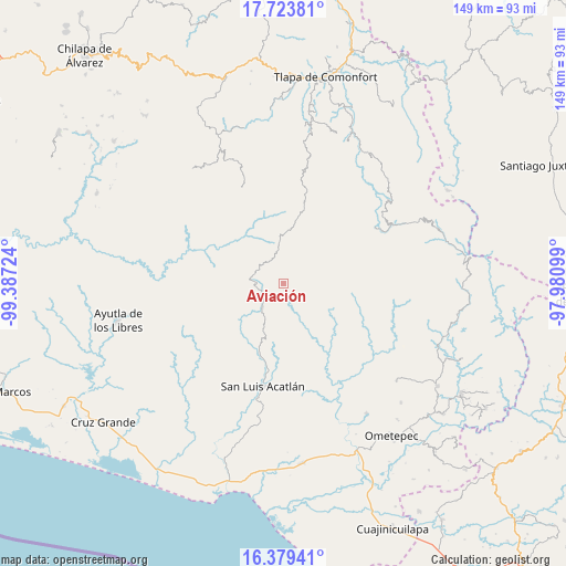
Aviación GPS coordinates[2]
17° 3' 10.152" North, 98° 41' 2.796" West
| Map corner | latitude | longitude |
|---|---|---|
| Upper-left | 17.72381°, | -99.38724° |
| Center: | 17.05282°, | -98.68411° |
| Lower-right: | 16.37941°, | -97.98099° |
| Map W x H: | 149.5×149.5 km | = 92.9×92.9mi |
| max Lat: | 32.7° ⇑88.2% North |
| Aviación: | 17.05282° |
| min Lat: | ⇓11.8% South 14.53588° |
| min Long | Aviación | max Long |
| -117.105° | -98.68411° | -86.73105° |
| W 55.3%⇐ | ⇒44.7% E |
Elevation
Elevation of Aviación is 1140 m = 3740 ft, and this is 113.7 m = 373 ft below average elevation for this country.
| Max E: |
3497 m = 11473 ft | 56.5% |
| Avg. | 1253.7 m = 4113 ft | |
| Aviación | 1140 m = 3740 ft | |
Min E: |
-1 m = -3 ft | 43.5% |
See also: Mexico elevation on elevation.city.
Geographical zone
Aviación is located in North Torrid zone (between Equator and Tropic of Cancer). Distance of this Northern Tropic circle is 709.8 km =441 mi to North.| Distance of | km | miles | from Aviación |
|---|---|---|---|
| North Pole | 8111 | 5039.9 | to North |
| Arctic Circle | 5505.1 | 3420.7 | to North |
| Tropic Cancer | 709.8 | 441 | to North |
| Equator | 1896.1 | 1178.2 | to South |


Nearby cities:
15 places around Aviación: (largest is in red/bold)
• Arroyo San Pedro
4.6 km =2.9 mi,  247°
247°
• Cerro Cuate
1.6 km =1 mi,  2°
2°
• Colombia de Guadalupe
8.9 km =5.5 mi,  296°
296°
• Cruztomáhuac
5 km =3.1 mi,  98°
98°
• El Aserradero
5.4 km =3.4 mi,  161°
161°
• El Potrerillo (Potrerillo del Rincón)
11.6 km =7.2 mi,  205°
205°
• El Rincón (Santa Cruz del Rincón)
8.3 km =5.2 mi,  220°
220°
• Iliatenco
0.8 km =0.5 mi,  194°
194°
• Paraje Montero (Paraje Montero de Zaragoza)
12.5 km =7.8 mi,  350°
350°
• Potrerillo Coapinole
9.9 km =6.2 mi, 193°
• Pueblo Hidalgo
11.6 km =7.2 mi,  165°
165°
• San José Vista Hermosa
6.8 km =4.2 mi,  177°
177°
• Tilapa
6.9 km =4.3 mi,  266°
266°
• Tlaxcalixtlahuaca
12.8 km =8 mi,  231°
231°
• Tuxtepec (Cofradía)
9.2 km =5.7 mi, 178°
Sources, notices
• [Note1] Compared only with cities in Mexico existing in our database
• [Src1] Map data: © OpenStreetMap contributors (CC-BY-SA)
• [Src2] Other city data from geonames.org with taken over terms of usage.
• [Src3] Geographical zone / Annual Mean Temperature by Robert A. Rohde @ Wikipedia
