Loma Vicente Guerrero geodata
Loma Vicente Guerrero (State of Mexico) is a populated place; located in Mexico in America/Mexico_City (GMT-6) time zone. With population of 556 people, there are 15345 cities with bigger population in this country. Compared to other cities in Mexico, 52.3% of cities are located further ↑North; 59.5% of cities are located further →East and 93.7% of cities have lower elevation than Loma Vicente Guerrero. Note1
Current local time in Loma Vicente Guerrero:
06:48 AM, WednesdayDifference from your time zone: hours


Loma Vicente Guerrero GPS coordinates[2]
19° 34' 59.016" North, 99° 39' 11.988" West
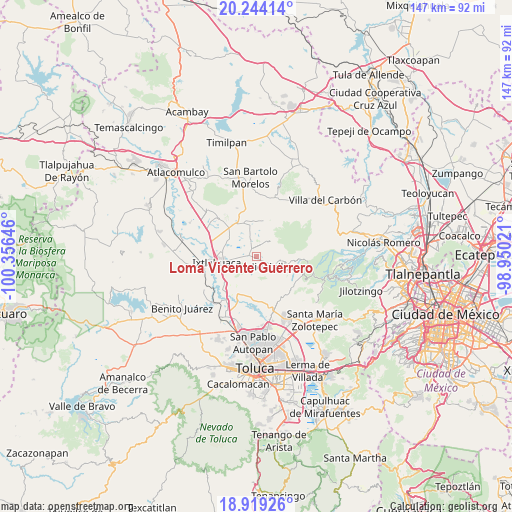
| Map corner | latitude | longitude |
|---|---|---|
| Upper-left | 20.24414°, | -100.35646° |
| Center: | 19.58306°, | -99.65333° |
| Lower-right: | 18.91926°, | -98.95021° |
| Map W x H: | 147.3×147.3 km | = 91.5×91.5mi |
| max Lat: | 32.7° ⇑52.3% North |
| Loma Vicente Guerrero: | 19.58306° |
| min Lat: | ⇓47.7% South 14.53588° |
| min Long | Loma Vicente Gu | max Long |
| -117.105° | -99.65333° | -86.73105° |
| W 40.5%⇐ | ⇒59.5% E |
Elevation
Elevation of Loma Vicente Guerrero is 2557 m = 8389 ft, and this is 1303.3 m = 4276 ft above average elevation for this country.
| Max E: |
3497 m = 11473 ft | 6.3% |
| Loma Vicente Guerrero | 2557 m 8389 ft | |
| Avg. | 1253.7 m = 4113 ft | |
Min E: |
-1 m = -3 ft | 93.7% |
See also: Mexico elevation on elevation.city.
Geographical zone
Loma Vicente Guerrero is located in North Torrid zone (between Equator and Tropic of Cancer). Distance of this Northern Tropic circle is 428.5 km =266.3 mi to North.| Distance of | km | miles | from Loma Vicente Guerrero |
|---|---|---|---|
| North Pole | 7829.6 | 4865.1 | to North |
| Arctic Circle | 5223.7 | 3245.9 | to North |
| Tropic Cancer | 428.5 | 266.3 | to North |
| Equator | 2177.4 | 1353 | to South |


Nearby cities:
15 places around Loma Vicente Guerrero: (largest is in red/bold)
• Buenos Aires
4.1 km =2.5 mi,  338°
338°
• Colonia la Purísima
2.4 km =1.5 mi,  254°
254°
• Ejido de Mañi
2.6 km =1.6 mi,  213°
213°
• Ejido de Santa María Nativitas
2.1 km =1.3 mi,  126°
126°
• Loma Hidalgo Colonia Benito Juárez
1.8 km =1.1 mi,  38°
38°
• Loma de San Felipe
1.5 km =0.9 mi,  287°
287°
• Loma del Astillero
2.1 km =1.3 mi,  277°
277°
• Loma del Madroño
5.5 km =3.4 mi,  170°
170°
• Manzana Tercera (Bodo)
5.5 km =3.4 mi,  103°
103°
• Manzana Tercera Loma de Hidalgo
0.8 km =0.5 mi,  347°
347°
• Moxteje
2.5 km =1.6 mi,  123°
123°
• San José del Sitio
2.6 km =1.6 mi,  328°
328°
• Santa María Nativitas
4.7 km =2.9 mi, 95°
• Sección del Cerrito
3.8 km =2.4 mi,  224°
224°
• Tierra Blanca
3.2 km =2 mi, 247°
Sources, notices
• [Note1] Compared only with cities in Mexico existing in our database
• [Src1] Map data: © OpenStreetMap contributors (CC-BY-SA)
• [Src2] Other city data from geonames.org with taken over terms of usage.
• [Src3] Geographical zone / Annual Mean Temperature by Robert A. Rohde @ Wikipedia
