Los Ailes geodata
Los Ailes (State of Mexico) is a populated place; located in Mexico in America/Mexico_City (GMT-6) time zone. With population of 545 people, there are 15598 cities with bigger population in this country. Compared to other cities in Mexico, 51% of cities are located further ↑North; 54% of cities are located further →East and 89.3% of cities have lower elevation than Los Ailes. Note1


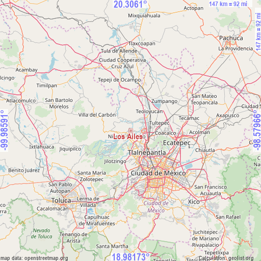
Los Ailes GPS coordinates[2]
19° 38' 43.008" North, 99° 16' 58.008" West
| Map corner | latitude | longitude |
|---|---|---|
| Upper-left | 20.3061°, | -99.98591° |
| Center: | 19.64528°, | -99.28278° |
| Lower-right: | 18.98173°, | -98.57966° |
| Map W x H: | 147.3×147.3 km | = 91.5×91.5mi |
| max Lat: | 32.7° ⇑51% North |
| Los Ailes: | 19.64528° |
| min Lat: | ⇓49% South 14.53588° |
| min Long | Los Ailes | max Long |
| -117.105° | -99.28278° | -86.73105° |
| W 46%⇐ | ⇒54% E |
Elevation
Elevation of Los Ailes is 2384 m = 7822 ft, and this is 1130.3 m = 3708 ft above average elevation for this country.
| Max E: |
3497 m = 11473 ft | 10.7% |
| Los Ailes | 2384 m 7822 ft | |
| Avg. | 1253.7 m = 4113 ft | |
Min E: |
-1 m = -3 ft | 89.3% |
See also: Mexico elevation on elevation.city.
Geographical zone
Los Ailes is located in North Torrid zone (between Equator and Tropic of Cancer). Distance of this Northern Tropic circle is 421.6 km =262 mi to North.| Distance of | km | miles | from Los Ailes |
|---|---|---|---|
| North Pole | 7822.7 | 4860.8 | to North |
| Arctic Circle | 5216.8 | 3241.6 | to North |
| Tropic Cancer | 421.6 | 262 | to North |
| Equator | 2184.4 | 1357.3 | to South |


Nearby cities:
15 places around Los Ailes: (largest is in red/bold)
• Colonia Morelos
6 km =3.7 mi,  261°
261°
• Ejido Santa María Tianguistenco (Ejido el Rosario)
1.9 km =1.2 mi,  58°
58°
• Ejido Santiago
6.4 km =4 mi,  17°
17°
• Ejido de Guadalupe
1.4 km =0.9 mi,  126°
126°
• El Cerrito
5.1 km =3.2 mi, 21°
• Huilango
4.8 km =3 mi,  35°
35°
• La Concepción
5.9 km =3.7 mi,  342°
342°
• La Luz
6 km =3.7 mi,  359°
359°
• Las Tinajas
4.3 km =2.7 mi,  54°
54°
• Loma Larga
6.9 km =4.3 mi,  253°
253°
• Loma de San José
4.7 km =2.9 mi,  265°
265°
• Nicolás Romero
2.5 km =1.6 mi, 261°
• San Pablo de los Gallos
5.2 km =3.2 mi, 47°
• Santa Cruz
6.1 km =3.8 mi, 22°
• Santiago Cuautlalpan
4.4 km =2.7 mi,  351°
351°
Sources, notices
• [Note1] Compared only with cities in Mexico existing in our database
• [Src1] Map data: © OpenStreetMap contributors (CC-BY-SA)
• [Src2] Other city data from geonames.org with taken over terms of usage.
• [Src3] Geographical zone / Annual Mean Temperature by Robert A. Rohde @ Wikipedia
