Villa Hermosa geodata
Villa Hermosa (Oaxaca) is a populated place; located in Mexico in America/Mexico_City (GMT-6) time zone. With population of 533 people, there are 15888 cities with bigger population in this country. Compared to other cities in Mexico, 96.3% of cities are located further ↑North; 84.2% of cities are located further ←West and 96.3% of cities have higher elevation than Villa Hermosa. Note1


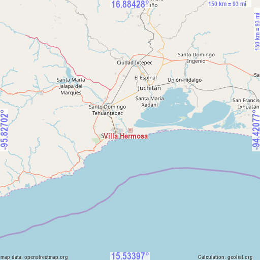
Villa Hermosa GPS coordinates[2]
16° 12' 37.008" North, 95° 7' 26.004" West
| Map corner | latitude | longitude |
|---|---|---|
| Upper-left | 16.88428°, | -95.82702° |
| Center: | 16.21028°, | -95.12389° |
| Lower-right: | 15.53397°, | -94.42077° |
| Map W x H: | 150.1×150.1 km | = 93.3×93.3mi |
| max Lat: | 32.7° ⇑96.3% North |
| Villa Hermosa: | 16.21028° |
| min Lat: | ⇓3.7% South 14.53588° |
| min Long | Villa Hermosa | max Long |
| -117.105° | -95.12389° | -86.73105° |
| W 84.2%⇐ | ⇒15.8% E |
Elevation
Elevation of Villa Hermosa is 11 m = 36 ft, and this is 1242.7 m = 4077 ft below average elevation for this country.
| Max E: |
3497 m = 11473 ft | 96.3% |
| Avg. | 1253.7 m = 4113 ft | |
| Villa Hermosa | 11 m = 36 ft | |
Min E: |
-1 m = -3 ft | 3.7% |
See also: Mexico elevation on elevation.city.
Geographical zone
Villa Hermosa is located in North Torrid zone (between Equator and Tropic of Cancer). Distance of this Northern Tropic circle is 803.5 km =499.3 mi to North.| Distance of | km | miles | from Villa Hermosa |
|---|---|---|---|
| North Pole | 8204.6 | 5098.1 | to North |
| Arctic Circle | 5598.8 | 3478.9 | to North |
| Tropic Cancer | 803.5 | 499.3 | to North |
| Equator | 1802.4 | 1120 | to South |


Nearby cities:
15 places around Villa Hermosa: (largest is in red/bold)
• Boca del Río
4 km =2.5 mi,  265°
265°
• Charis
10 km =6.2 mi,  18°
18°
• Colonia Cuauhtémoc
2.3 km =1.4 mi,  170°
170°
• Colonia Juárez
10.3 km =6.4 mi,  90°
90°
• Colonia Santita
11 km =6.8 mi,  246°
246°
• Fraccionamiento 25 de Enero
8 km =5 mi,  309°
309°
• Huazantlán del Río
1.1 km =0.7 mi,  333°
333°
• La Noria
11.4 km =7.1 mi,  295°
295°
• Salina Cruz
8.5 km =5.3 mi,  242°
242°
• San Blas Atempa
17.3 km =10.7 mi,  321°
321°
• San Mateo del Mar
15.1 km =9.4 mi, 89°
• San Pedro Huilotepec
4.9 km =3 mi, 324°
• Santa Rosa
12.1 km =7.5 mi,  12°
12°
• Santo Domingo Tehuantepec
17.8 km =11.1 mi, 315°
• Álvaro Obregón
10.7 km =6.6 mi, 23°
Sources, notices
• [Note1] Compared only with cities in Mexico existing in our database
• [Src1] Map data: © OpenStreetMap contributors (CC-BY-SA)
• [Src2] Other city data from geonames.org with taken over terms of usage.
• [Src3] Geographical zone / Annual Mean Temperature by Robert A. Rohde @ Wikipedia
