El Campamento geodata
El Campamento (Baja California Sur) is a populated place; located in Mexico in America/Mazatlan (GMT-7) time zone. With population of 531 people, there are 15939 cities with bigger population in this country. Compared to other cities in Mexico, 89% of cities are located further ↓South; 97.8% of cities are located further →East and 80.3% of cities have higher elevation than El Campamento. Note1


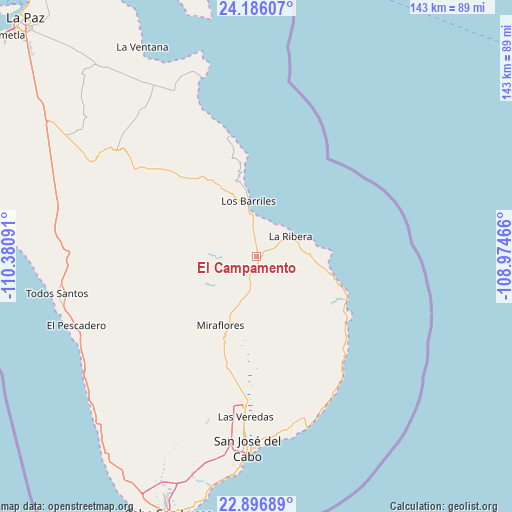
El Campamento GPS coordinates[2]
23° 32' 35.016" North, 109° 40' 40.008" West
| Map corner | latitude | longitude |
|---|---|---|
| Upper-left | 24.18607°, | -110.38091° |
| Center: | 23.54306°, | -109.67778° |
| Lower-right: | 22.89689°, | -108.97466° |
| Map W x H: | 143.3×143.3 km | = 89×89mi |
| max Lat: | 32.7° ⇑11% North |
| El Campamento: | 23.54306° |
| min Lat: | ⇓89% South 14.53588° |
| min Long | El Campamento | max Long |
| -117.105° | -109.67778° | -86.73105° |
| W 2.2%⇐ | ⇒97.8% E |
Elevation
Elevation of El Campamento is 91 m = 299 ft, and this is 1162.7 m = 3815 ft below average elevation for this country.
| Max E: |
3497 m = 11473 ft | 80.3% |
| Avg. | 1253.7 m = 4113 ft | |
| El Campamento | 91 m = 299 ft | |
Min E: |
-1 m = -3 ft | 19.7% |
See also: Mexico elevation on elevation.city.
Geographical zone
El Campamento is located in North temperate zone (between Tropic of Cancer and the Arctic Circle). Distance of this Northern Tropic circle is 11.8 km =7.3 mi to South.| Distance of | km | miles | from El Campamento |
|---|---|---|---|
| North Pole | 7389.3 | 4591.5 | to North |
| Arctic Circle | 4783.4 | 2972.3 | to North |
| Tropic Cancer | 11.8 | 7.3 | to South |
| Equator | 2617.7 | 1626.6 | to South |


Nearby cities:
15 places around El Campamento: (largest is in red/bold)
• Buena Vista
11.5 km =7.1 mi,  356°
356°
• El Pescadero
53.8 km =33.4 mi,  248°
248°
• Fraccionamiento la Ballena Segunda Etapa
45.7 km =28.4 mi,  186°
186°
• General Juán Domínguez Cota
55.3 km =34.4 mi,  329°
329°
• La Playa
53.3 km =33.1 mi,  178°
178°
• La Rivera
11 km =6.8 mi,  58°
58°
• Las Veredas
43.8 km =27.2 mi, 183°
• Los Barriles
15.7 km =9.8 mi,  351°
351°
• Miraflores
21.6 km =13.4 mi,  207°
207°
• San José del Cabo
53.9 km =33.5 mi, 182°
• San Juan de los Planes
53.9 km =33.5 mi, 330°
• Santa Anita
40.5 km =25.2 mi, 183°
• Santa Catarina
45.4 km =28.2 mi, 181°
• Santiago
8.1 km =5 mi, 207°
• Todos Santos
56.6 km =35.2 mi,  259°
259°
Sources, notices
• [Note1] Compared only with cities in Mexico existing in our database
• [Src1] Map data: © OpenStreetMap contributors (CC-BY-SA)
• [Src2] Other city data from geonames.org with taken over terms of usage.
• [Src3] Geographical zone / Annual Mean Temperature by Robert A. Rohde @ Wikipedia
