El Pescadero geodata
El Pescadero (Baja California Sur) is a populated place; located in Mexico in America/Mazatlan (GMT-7) time zone. With population of 2,338 people, there are 3775 cities with bigger population in this country. Compared to other cities in Mexico, 88.7% of cities are located further ↓South; 98.3% of cities are located further →East and 83.8% of cities have higher elevation than El Pescadero. Note1


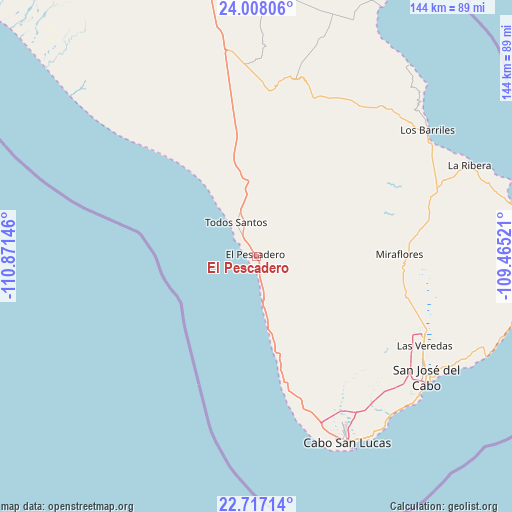
El Pescadero GPS coordinates[2]
23° 21' 51.012" North, 110° 10' 5.988" West
| Map corner | latitude | longitude |
|---|---|---|
| Upper-left | 24.00806°, | -110.87146° |
| Center: | 23.36417°, | -110.16833° |
| Lower-right: | 22.71714°, | -109.46521° |
| Map W x H: | 143.5×143.5 km | = 89.2×89.2mi |
| max Lat: | 32.7° ⇑11.3% North |
| El Pescadero: | 23.36417° |
| min Lat: | ⇓88.7% South 14.53588° |
| min Long | El Pescadero | max Long |
| -117.105° | -110.16833° | -86.73105° |
| W 1.7%⇐ | ⇒98.3% E |
Elevation
Elevation of El Pescadero is 53 m = 174 ft, and this is 1200.7 m = 3939 ft below average elevation for this country.
| Max E: |
3497 m = 11473 ft | 83.8% |
| Avg. | 1253.7 m = 4113 ft | |
| El Pescadero | 53 m = 174 ft | |
Min E: |
-1 m = -3 ft | 16.2% |
See also: Mexico elevation on elevation.city.
Geographical zone
El Pescadero is located in North Torrid zone (between Equator and Tropic of Cancer). Distance of this Northern Tropic circle is 8.1 km =5 mi to North.| Distance of | km | miles | from El Pescadero |
|---|---|---|---|
| North Pole | 7409.2 | 4603.9 | to North |
| Arctic Circle | 4803.3 | 2984.6 | to North |
| Tropic Cancer | 8.1 | 5 | to North |
| Equator | 2597.9 | 1614.3 | to South |


Nearby cities:
15 places around El Pescadero: (largest is in red/bold)
• Buena Vista
58.5 km =36.4 mi,  57°
57°
• Colonia del Sol
56 km =34.8 mi,  153°
153°
• El Cachanilla
41 km =25.5 mi,  343°
343°
• El Campamento
53.8 km =33.4 mi,  68°
68°
• El Carrizal
48.9 km =30.4 mi, 342°
• El Tezal
58.4 km =36.3 mi, 151°
• Fraccionamiento la Ballena Segunda Etapa
51.7 km =32.1 mi,  119°
119°
• Las Palmas
52.8 km =32.8 mi, 154°
• Las Veredas
52.9 km =32.9 mi, 116°
• Melitón Albáñez Domínguez
41.9 km =26 mi,  322°
322°
• Miraflores
40.2 km =25 mi,  89°
89°
• Santa Anita
51.9 km =32.2 mi,  113°
113°
• Santa Catarina
55.1 km =34.2 mi, 117°
• Santiago
48 km =29.8 mi, 74°
• Todos Santos
10.8 km =6.7 mi,  328°
328°
Sources, notices
• [Note1] Compared only with cities in Mexico existing in our database
• [Src1] Map data: © OpenStreetMap contributors (CC-BY-SA)
• [Src2] Other city data from geonames.org with taken over terms of usage.
• [Src3] Geographical zone / Annual Mean Temperature by Robert A. Rohde @ Wikipedia
