El Parnaso geodata
El Parnaso (Tabasco) is a populated place; located in Mexico in America/Mexico_City (GMT-6) time zone. With population of 531 people, there are 15939 cities with bigger population in this country. Compared to other cities in Mexico, 78.6% of cities are located further ↑North; 86.6% of cities are located further ←West and 89.4% of cities have higher elevation than El Parnaso. Note1


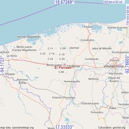
El Parnaso GPS coordinates[2]
18° 0' 19.008" North, 93° 28' 9.012" West
| Map corner | latitude | longitude |
|---|---|---|
| Upper-left | 18.67269°, | -94.1723° |
| Center: | 18.00528°, | -93.46917° |
| Lower-right: | 17.33533°, | -92.76605° |
| Map W x H: | 148.7×148.7 km | = 92.4×92.4mi |
| max Lat: | 32.7° ⇑78.6% North |
| El Parnaso: | 18.00528° |
| min Lat: | ⇓21.4% South 14.53588° |
| min Long | El Parnaso | max Long |
| -117.105° | -93.46917° | -86.73105° |
| W 86.6%⇐ | ⇒13.4% E |
Elevation
Elevation of El Parnaso is 26 m = 85 ft, and this is 1227.7 m = 4028 ft below average elevation for this country.
| Max E: |
3497 m = 11473 ft | 89.4% |
| Avg. | 1253.7 m = 4113 ft | |
| El Parnaso | 26 m = 85 ft | |
Min E: |
-1 m = -3 ft | 10.6% |
See also: Mexico elevation on elevation.city.
Geographical zone
El Parnaso is located in North Torrid zone (between Equator and Tropic of Cancer). Distance of this Northern Tropic circle is 603.9 km =375.2 mi to North.| Distance of | km | miles | from El Parnaso |
|---|---|---|---|
| North Pole | 8005.1 | 4974.1 | to North |
| Arctic Circle | 5399.2 | 3354.9 | to North |
| Tropic Cancer | 603.9 | 375.2 | to North |
| Equator | 2002 | 1244 | to South |


Nearby cities:
15 places around El Parnaso: (largest is in red/bold)
• Arroyo Hondo Abejonal
6.9 km =4.3 mi,  116°
116°
• Bajío 1ra. Sección A (Perifércio Sur)
12.3 km =7.6 mi,  100°
100°
• C-32 (Licenciado Francisco Trujillo Gurría)
5.3 km =3.3 mi,  219°
219°
• C-41 (Licenciado Carlos A. Madrazo)
9.4 km =5.8 mi,  166°
166°
• Celia González de Rovirosa
12.3 km =7.6 mi,  60°
60°
• Cárdenas
9.9 km =6.2 mi,  92°
92°
• De los Santos
12.1 km =7.5 mi, 59°
• La Península
13.3 km =8.3 mi, 121°
• Melchor Ocampo
11.8 km =7.3 mi,  72°
72°
• Poblado C-21 Licenciado Benito Juárez García
12 km =7.5 mi,  305°
305°
• Poblado C-33 20 de Noviembre
11 km =6.8 mi,  247°
247°
• Río Seco 2da. Sección C
13.2 km =8.2 mi,  48°
48°
• Santana 5ta. Sección (El Espino)
13.3 km =8.3 mi,  14°
14°
• Sección 10 de Azucareros
12.6 km =7.8 mi, 116°
• Tecominoacán
13.6 km =8.5 mi,  226°
226°
Sources, notices
• [Note1] Compared only with cities in Mexico existing in our database
• [Src1] Map data: © OpenStreetMap contributors (CC-BY-SA)
• [Src2] Other city data from geonames.org with taken over terms of usage.
• [Src3] Geographical zone / Annual Mean Temperature by Robert A. Rohde @ Wikipedia
