La Alicia geodata
La Alicia (Oaxaca) is a populated place; located in Mexico in America/Mexico_City (GMT-6) time zone. With population of 503 people, there are 16722 cities with bigger population in this country. Compared to other cities in Mexico, 81.8% of cities are located further ↑North; 82.2% of cities are located further ←West and 79.7% of cities have higher elevation than La Alicia. Note1


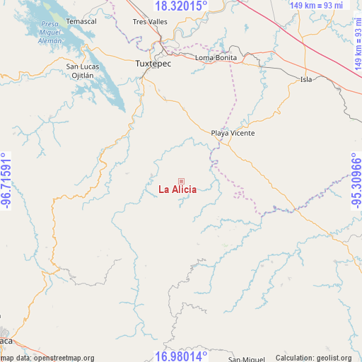
La Alicia GPS coordinates[2]
17° 39' 5.004" North, 96° 0' 46.008" West
| Map corner | latitude | longitude |
|---|---|---|
| Upper-left | 18.32015°, | -96.71591° |
| Center: | 17.65139°, | -96.01278° |
| Lower-right: | 16.98014°, | -95.30966° |
| Map W x H: | 149×149 km | = 92.6×92.6mi |
| max Lat: | 32.7° ⇑81.8% North |
| La Alicia: | 17.65139° |
| min Lat: | ⇓18.2% South 14.53588° |
| min Long | La Alicia | max Long |
| -117.105° | -96.01278° | -86.73105° |
| W 82.2%⇐ | ⇒17.8% E |
Elevation
Elevation of La Alicia is 99 m = 325 ft, and this is 1154.7 m = 3788 ft below average elevation for this country.
| Max E: |
3497 m = 11473 ft | 79.7% |
| Avg. | 1253.7 m = 4113 ft | |
| La Alicia | 99 m = 325 ft | |
Min E: |
-1 m = -3 ft | 20.3% |
See also: Mexico elevation on elevation.city.
Geographical zone
La Alicia is located in North Torrid zone (between Equator and Tropic of Cancer). Distance of this Northern Tropic circle is 643.3 km =399.7 mi to North.| Distance of | km | miles | from La Alicia |
|---|---|---|---|
| North Pole | 8044.4 | 4998.6 | to North |
| Arctic Circle | 5438.5 | 3379.3 | to North |
| Tropic Cancer | 643.3 | 399.7 | to North |
| Equator | 1962.7 | 1219.6 | to South |


Nearby cities:
15 places around La Alicia: (largest is in red/bold)
• Arroyo Blanco
20.2 km =12.6 mi,  127°
127°
• Arroyo de Piedra
19.5 km =12.1 mi,  116°
116°
• Asunción Lachixila
20.3 km =12.6 mi,  240°
240°
• Ayotzintepec
12.5 km =7.8 mi,  280°
280°
• Ignacio Zaragoza
18 km =11.2 mi,  135°
135°
• La Josefina
13.7 km =8.5 mi,  272°
272°
• Montenegro la Lana
16.9 km =10.5 mi,  112°
112°
• Paso de San Jacobo
13.6 km =8.5 mi,  90°
90°
• Río Chiquito
8.8 km =5.5 mi, 113°
• San Antonio las Palmas
8.6 km =5.3 mi,  285°
285°
• San José Río Manzo
14.2 km =8.8 mi,  81°
81°
• San Juan Toavela
14.9 km =9.3 mi,  201°
201°
• Santa María Lovani
16.7 km =10.4 mi,  205°
205°
• Santiago Jocotepec
14.8 km =9.2 mi,  150°
150°
• Tomate Río Manso
17.5 km =10.9 mi,  58°
58°
Sources, notices
• [Note1] Compared only with cities in Mexico existing in our database
• [Src1] Map data: © OpenStreetMap contributors (CC-BY-SA)
• [Src2] Other city data from geonames.org with taken over terms of usage.
• [Src3] Geographical zone / Annual Mean Temperature by Robert A. Rohde @ Wikipedia
