Ayotzintepec geodata
Ayotzintepec (Oaxaca) is a populated place; located in Mexico in America/Mexico_City (GMT-6) time zone. With population of 3,609 people, there are 2541 cities with bigger population in this country. Compared to other cities in Mexico, 81.5% of cities are located further ↑North; 81.7% of cities are located further ←West and 78.3% of cities have higher elevation than Ayotzintepec. Note1


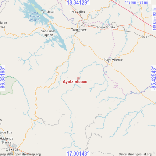
Ayotzintepec GPS coordinates[2]
17° 40' 21.396" North, 96° 7' 42.78" West
| Map corner | latitude | longitude |
|---|---|---|
| Upper-left | 18.34129°, | -96.83168° |
| Center: | 17.67261°, | -96.12855° |
| Lower-right: | 17.00143°, | -95.42543° |
| Map W x H: | 149×149 km | = 92.6×92.6mi |
| max Lat: | 32.7° ⇑81.5% North |
| Ayotzintepec: | 17.67261° |
| min Lat: | ⇓18.5% South 14.53588° |
| min Long | Ayotzintepec | max Long |
| -117.105° | -96.12855° | -86.73105° |
| W 81.7%⇐ | ⇒18.3% E |
Elevation
Elevation of Ayotzintepec is 124 m = 407 ft, and this is 1129.7 m = 3706 ft below average elevation for this country.
| Max E: |
3497 m = 11473 ft | 78.3% |
| Avg. | 1253.7 m = 4113 ft | |
| Ayotzintepec | 124 m = 407 ft | |
Min E: |
-1 m = -3 ft | 21.7% |
See also: Mexico elevation on elevation.city.
Geographical zone
Ayotzintepec is located in North Torrid zone (between Equator and Tropic of Cancer). Distance of this Northern Tropic circle is 640.9 km =398.2 mi to North.| Distance of | km | miles | from Ayotzintepec |
|---|---|---|---|
| North Pole | 8042.1 | 4997.1 | to North |
| Arctic Circle | 5436.2 | 3377.9 | to North |
| Tropic Cancer | 640.9 | 398.2 | to North |
| Equator | 1965 | 1221 | to South |


Nearby cities:
15 places around Ayotzintepec: (largest is in red/bold)
• Asunción Lachixila
13.4 km =8.3 mi,  204°
204°
• Cerro Concha
19.1 km =11.9 mi,  339°
339°
• Cerro Marín (Monte Flor)
20.7 km =12.9 mi,  313°
313°
• La Alicia
12.5 km =7.8 mi,  100°
100°
• La Josefina
2.2 km =1.4 mi,  219°
219°
• La Rinconada
12 km =7.5 mi,  321°
321°
• Paso Nuevo la Hamaca
14.1 km =8.8 mi, 313°
• Río Chiquito
21.1 km =13.1 mi,  106°
106°
• San Antonio las Palmas
4 km =2.5 mi,  91°
91°
• San Francisco Yovego
16.8 km =10.4 mi, 216°
• San Isidro Chinantilla
19.9 km =12.4 mi, 324°
• San Juan Toavela
17.5 km =10.9 mi,  157°
157°
• San Pedro Ozumacín
10.3 km =6.4 mi,  273°
273°
• Santa María Lovani
18.2 km =11.3 mi, 163°
• Vega del Sol
17.9 km =11.1 mi,  328°
328°
Sources, notices
• [Note1] Compared only with cities in Mexico existing in our database
• [Src1] Map data: © OpenStreetMap contributors (CC-BY-SA)
• [Src2] Other city data from geonames.org with taken over terms of usage.
• [Src3] Geographical zone / Annual Mean Temperature by Robert A. Rohde @ Wikipedia
