Kuala Pilah geodata
Kuala Pilah (Negeri Sembilan) is a populated place; located in Malaysia in Asia/Kuala_Lumpur (GMT+8) time zone. With population of 19,510 people, there are 122 cities with bigger population in this country. Compared to other cities in Malaysia, 71.9% of cities are located further ↑North; 56.7% of cities are located further ←West and 94.9% of cities have lower elevation than Kuala Pilah. Note1


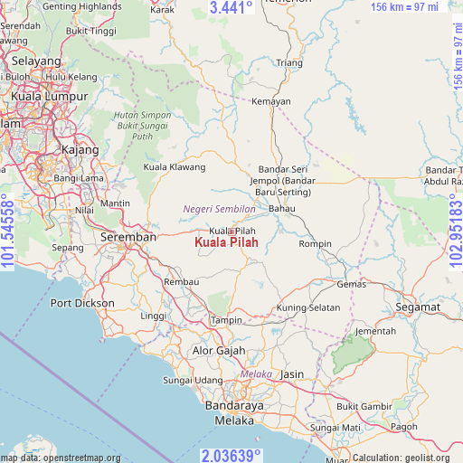
Kuala Pilah GPS coordinates[2]
2° 44' 20.04" North, 102° 14' 55.32" East
| Map corner | latitude | longitude |
|---|---|---|
| Upper-left | 3.441°, | 101.54558° |
| Center: | 2.7389°, | 102.2487° |
| Lower-right: | 2.03639°, | 102.95183° |
| Map W x H: | 156.2×156.2 km | = 97.1×97.1mi |
| max Lat: | 6.88732° ⇑71.9% North |
| Kuala Pilah: | 2.7389° |
| min Lat: | ⇓28.1% South 1.24722° |
| min Long | Kuala Pilah | max Long |
| 99.68252° | 102.2487° | 118.61119° |
| W 56.7%⇐ | ⇒43.3% E |
Elevation
Elevation of Kuala Pilah is 93 m = 305 ft, and this is 48.3 m = 158 ft above average elevation for this country.
| Max E: |
1488 m = 4882 ft | 5.1% |
| Kuala Pilah | 93 m 305 ft | |
| Avg. | 44.7 m = 147 ft | |
Min E: |
0 m = 0 ft | 94.9% |
See also: Malaysia elevation on elevation.city.
Geographical zone
Kuala Pilah is located in North Torrid zone (between Equator and Tropic of Cancer). Distance of Equator is 304.5 km =189.2 mi to South.| Distance of | km | miles | from Kuala Pilah |
|---|---|---|---|
| North Pole | 9702.5 | 6028.9 | to North |
| Arctic Circle | 7096.6 | 4409.6 | to North |
| Tropic Cancer | 2301.4 | 1430 | to North |
| Equator | 304.5 | 189.2 | to South |


Nearby cities:
15 places around Kuala Pilah: (largest is in red/bold)
• Alor Gajah
40.1 km =24.9 mi,  186°
186°
• Bahau
19 km =11.8 mi,  66°
66°
• Batu Berendam
54.5 km =33.9 mi,  180°
180°
• Bemban
54.2 km =33.7 mi,  165°
165°
• Bukit Rambai
53.8 km =33.4 mi, 187°
• Kampong Masjid Tanah
45.7 km =28.4 mi,  198°
198°
• Kampung Ayer Keroh
52.8 km =32.8 mi, 176°
• Kampung Baharu Nilai
50.7 km =31.5 mi,  278°
278°
• Kuala Sungai Baru
48.4 km =30.1 mi,  209°
209°
• Port Dickson
54.1 km =33.6 mi,  245°
245°
• Pulau Sebang
31.6 km =19.6 mi, 183°
• Semenyih
50.9 km =31.6 mi,  297°
297°
• Seremban
34.5 km =21.4 mi,  268°
268°
• Sungai Udang
53.6 km =33.3 mi, 192°
• Tampin
30 km =18.6 mi, 183°
Sources, notices
• [Note1] Compared only with cities in Malaysia existing in our database
• [Src1] Map data: © OpenStreetMap contributors (CC-BY-SA)
• [Src2] Other city data from geonames.org with taken over terms of usage.
• [Src3] Geographical zone / Annual Mean Temperature by Robert A. Rohde @ Wikipedia
