Seremban geodata
Seremban (Negeri Sembilan) is a seat of a first-order administrative division; located in Malaysia in Asia/Kuala_Lumpur (GMT+8) time zone. With population of 372,917 people, there are 12 cities with bigger population in this country. Compared to other cities in Malaysia, 72.5% of cities are located further ↑North; 55.1% of cities are located further →East and 90.4% of cities have lower elevation than Seremban. Note1


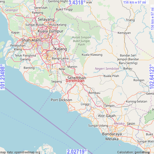
Seremban GPS coordinates[2]
2° 43' 46.92" North, 101° 56' 17.16" East
| Map corner | latitude | longitude |
|---|---|---|
| Upper-left | 3.4318°, | 101.23498° |
| Center: | 2.7297°, | 101.9381° |
| Lower-right: | 2.02719°, | 102.64123° |
| Map W x H: | 156.2×156.2 km | = 97.1×97.1mi |
| max Lat: | 6.88732° ⇑72.5% North |
| Seremban: | 2.7297° |
| min Lat: | ⇓27.5% South 1.24722° |
| min Long | Seremban | max Long |
| 99.68252° | 101.9381° | 118.61119° |
| W 44.9%⇐ | ⇒55.1% E |
Elevation
Elevation of Seremban is 59 m = 194 ft, and this is 14.3 m = 47 ft above average elevation for this country.
| Max E: |
1488 m = 4882 ft | 9.6% |
| Seremban | 59 m 194 ft | |
| Avg. | 44.7 m = 147 ft | |
Min E: |
0 m = 0 ft | 90.4% |
See also: Seremban elevation on elevation.city.
Geographical zone
Seremban is located in North Torrid zone (between Equator and Tropic of Cancer). Distance of Equator is 303.5 km =188.6 mi to South.| Distance of | km | miles | from Seremban |
|---|---|---|---|
| North Pole | 9703.5 | 6029.5 | to North |
| Arctic Circle | 7097.7 | 4410.3 | to North |
| Tropic Cancer | 2302.4 | 1430.6 | to North |
| Equator | 303.5 | 188.6 | to South |


Nearby cities:
15 places around Seremban: (largest is in red/bold)
• Alor Gajah
49.1 km =30.5 mi,  142°
142°
• Banting
49.3 km =30.6 mi,  280°
280°
• Kampong Baharu Balakong
39.7 km =24.7 mi,  328°
328°
• Kampong Masjid Tanah
46.6 km =29 mi,  154°
154°
• Kampung Baharu Nilai
17.7 km =11 mi,  297°
297°
• Kuala Pilah
34.5 km =21.4 mi,  88°
88°
• Kuala Sungai Baru
42.6 km =26.5 mi,  165°
165°
• Port Dickson
26 km =16.2 mi,  214°
214°
• Pulau Sebang
44.8 km =27.8 mi,  133°
133°
• Putrajaya
35.7 km =22.2 mi,  309°
309°
• Semenyih
26.8 km =16.7 mi,  336°
336°
• Sepang
21.3 km =13.2 mi,  258°
258°
• Sungai Pelek New Village
27.9 km =17.3 mi,  251°
251°
• Tampin
43.4 km =27 mi, 131°
• Tanjung Sepat
42.4 km =26.3 mi, 259°
Sources, notices
• [Note1] Compared only with cities in Malaysia existing in our database
• [Src1] Map data: © OpenStreetMap contributors (CC-BY-SA)
• [Src2] Other city data from geonames.org with taken over terms of usage.
• [Src3] Geographical zone / Annual Mean Temperature by Robert A. Rohde @ Wikipedia
