Butterworth geodata
Butterworth (Penang) is a populated place; located in Malaysia in Asia/Kuala_Lumpur (GMT+8) time zone. With population of 107,591 people, there are 36 cities with bigger population in this country. Compared to other cities in Malaysia, 72.5% of cities are located further ↓South; 89.3% of cities are located further →East and 88.8% of cities have higher elevation than Butterworth. Note1


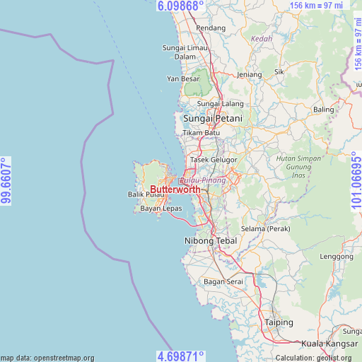
Butterworth GPS coordinates[2]
5° 23' 56.76" North, 100° 21' 49.752" East
| Map corner | latitude | longitude |
|---|---|---|
| Upper-left | 6.09868°, | 99.6607° |
| Center: | 5.3991°, | 100.36382° |
| Lower-right: | 4.69871°, | 101.06695° |
| Map W x H: | 155.7×155.7 km | = 96.7×96.7mi |
| max Lat: | 6.88732° ⇑27.5% North |
| Butterworth: | 5.3991° |
| min Lat: | ⇓72.5% South 1.24722° |
| min Long | Butterworth | max Long |
| 99.68252° | 100.36382° | 118.61119° |
| W 10.7%⇐ | ⇒89.3% E |
Elevation
Elevation of Butterworth is 6 m = 20 ft, and this is 38.7 m = 127 ft below average elevation for this country.
| Max E: |
1488 m = 4882 ft | 88.8% |
| Avg. | 44.7 m = 147 ft | |
| Butterworth | 6 m = 20 ft | |
Min E: |
0 m = 0 ft | 11.2% |
See also: Butterworth elevation on elevation.city.
Geographical zone
Butterworth is located in North Torrid zone (between Equator and Tropic of Cancer). Distance of Equator is 600.3 km =373 mi to South.| Distance of | km | miles | from Butterworth |
|---|---|---|---|
| North Pole | 9406.7 | 5845.1 | to North |
| Arctic Circle | 6800.9 | 4225.9 | to North |
| Tropic Cancer | 2005.6 | 1246.2 | to North |
| Equator | 600.3 | 373 | to South |


Nearby cities:
15 places around Butterworth: (largest is in red/bold)
• Batu Feringgi
15.4 km =9.6 mi,  301°
301°
• Bukit Mertajam
12.1 km =7.5 mi,  109°
109°
• George Town
3.4 km =2.1 mi,  293°
293°
• Juru
13 km =8.1 mi,  138°
138°
• Kampung Batu Feringgi
15.4 km =9.6 mi, 300°
• Kampung Sungai Ara
12.8 km =8 mi,  231°
231°
• Kepala Batas
14.8 km =9.2 mi,  27°
27°
• Kulim
22.2 km =13.8 mi,  99°
99°
• Nibong Tebal
28.8 km =17.9 mi,  154°
154°
• Perai
2.8 km =1.7 mi,  129°
129°
• Permatang Kuching
7.4 km =4.6 mi,  15°
15°
• Sungai Petani
30.8 km =19.1 mi, 26°
• Tanjung Tokong
9.3 km =5.8 mi,  317°
317°
• Tasek Glugor
17.4 km =10.8 mi,  58°
58°
• Telaga Batu
16.3 km =10.1 mi, 297°
Sources, notices
• [Note1] Compared only with cities in Malaysia existing in our database
• [Src1] Map data: © OpenStreetMap contributors (CC-BY-SA)
• [Src2] Other city data from geonames.org with taken over terms of usage.
• [Src3] Geographical zone / Annual Mean Temperature by Robert A. Rohde @ Wikipedia
