Klebang Besar geodata
Klebang Besar (Melaka) is a populated place; located in Malaysia in Asia/Kuala_Lumpur (GMT+8) time zone. With population of 38,643 people, there are 77 cities with bigger population in this country. Compared to other cities in Malaysia, 86.5% of cities are located further ↑North; 51.1% of cities are located further ←West and 94.4% of cities have higher elevation than Klebang Besar. Note1


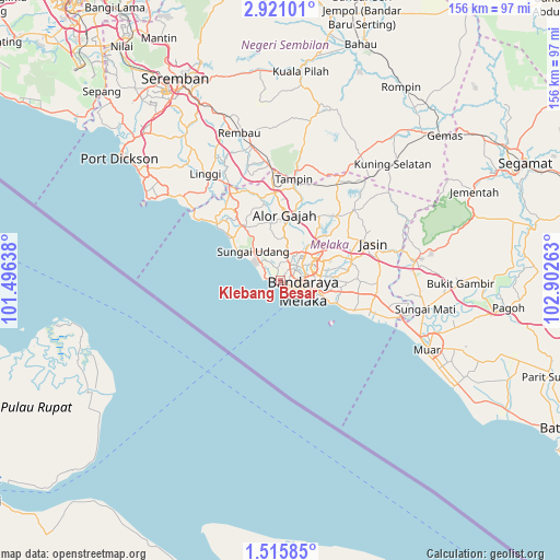
Klebang Besar GPS coordinates[2]
2° 13' 6.96" North, 102° 11' 58.2" East
| Map corner | latitude | longitude |
|---|---|---|
| Upper-left | 2.92101°, | 101.49638° |
| Center: | 2.2186°, | 102.1995° |
| Lower-right: | 1.51585°, | 102.90263° |
| Map W x H: | 156.2×156.2 km | = 97.1×97.1mi |
| max Lat: | 6.88732° ⇑86.5% North |
| Klebang Besar: | 2.2186° |
| min Lat: | ⇓13.5% South 1.24722° |
| min Long | Klebang Besar | max Long |
| 99.68252° | 102.1995° | 118.61119° |
| W 51.1%⇐ | ⇒48.9% E |
Elevation
Elevation of Klebang Besar is 5 m = 16 ft, and this is 39.7 m = 130 ft below average elevation for this country.
| Max E: |
1488 m = 4882 ft | 94.4% |
| Avg. | 44.7 m = 147 ft | |
| Klebang Besar | 5 m = 16 ft | |
Min E: |
0 m = 0 ft | 5.6% |
See also: Malaysia elevation on elevation.city.
Geographical zone
Klebang Besar is located in North Torrid zone (between Equator and Tropic of Cancer). Distance of Equator is 246.7 km =153.3 mi to South.| Distance of | km | miles | from Klebang Besar |
|---|---|---|---|
| North Pole | 9760.4 | 6064.8 | to North |
| Arctic Circle | 7154.5 | 4445.6 | to North |
| Tropic Cancer | 2359.2 | 1465.9 | to North |
| Equator | 246.7 | 153.3 | to South |


Nearby cities:
15 places around Klebang Besar: (largest is in red/bold)
• Alor Gajah
18 km =11.2 mi,  3°
3°
• Batu Berendam
6.2 km =3.9 mi,  57°
57°
• Bemban
20.2 km =12.6 mi,  74°
74°
• Bukit Rambai
4.9 km =3 mi,  338°
338°
• Kampong Masjid Tanah
17.3 km =10.7 mi,  327°
327°
• Kampung Ayer Keroh
10.4 km =6.5 mi, 59°
• Kampung Ayer Molek
14.3 km =8.9 mi,  92°
92°
• Kampung Bukit Baharu
9.5 km =5.9 mi, 92°
• Kuala Sungai Baru
24 km =14.9 mi,  310°
310°
• Malacca
5.2 km =3.2 mi,  118°
118°
• Muar
45.4 km =28.2 mi, 115°
• Pulau Sebang
26.5 km =16.5 mi,  8°
8°
• Sungai Udang
8.4 km =5.2 mi, 311°
• Tampin
28.2 km =17.5 mi, 6°
• Tangkak
38.8 km =24.1 mi,  81°
81°
Sources, notices
• [Note1] Compared only with cities in Malaysia existing in our database
• [Src1] Map data: © OpenStreetMap contributors (CC-BY-SA)
• [Src2] Other city data from geonames.org with taken over terms of usage.
• [Src3] Geographical zone / Annual Mean Temperature by Robert A. Rohde @ Wikipedia
