Muar geodata
Muar (Johor) is a populated place; located in Malaysia in Asia/Kuala_Lumpur (GMT+8) time zone. With population of 127,897 people, there are 33 cities with bigger population in this country. Compared to other cities in Malaysia, 89.3% of cities are located further ↑North; 65.2% of cities are located further ←West and 88.8% of cities have higher elevation than Muar. Note1


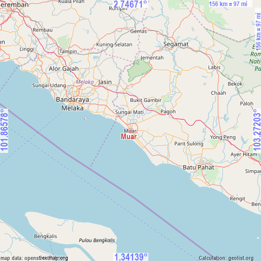
Muar GPS coordinates[2]
2° 2' 39.12" North, 102° 34' 8.04" East
| Map corner | latitude | longitude |
|---|---|---|
| Upper-left | 2.74671°, | 101.86578° |
| Center: | 2.0442°, | 102.5689° |
| Lower-right: | 1.34139°, | 103.27203° |
| Map W x H: | 156.3×156.3 km | = 97.1×97.1mi |
| max Lat: | 6.88732° ⇑89.3% North |
| Muar: | 2.0442° |
| min Lat: | ⇓10.7% South 1.24722° |
| min Long | Muar | max Long |
| 99.68252° | 102.5689° | 118.61119° |
| W 65.2%⇐ | ⇒34.8% E |
Elevation
Elevation of Muar is 6 m = 20 ft, and this is 38.7 m = 127 ft below average elevation for this country.
| Max E: |
1488 m = 4882 ft | 88.8% |
| Avg. | 44.7 m = 147 ft | |
| Muar | 6 m = 20 ft | |
Min E: |
0 m = 0 ft | 11.2% |
See also: Muar elevation on elevation.city.
Geographical zone
Muar is located in North Torrid zone (between Equator and Tropic of Cancer). Distance of Equator is 227.3 km =141.2 mi to South.| Distance of | km | miles | from Muar |
|---|---|---|---|
| North Pole | 9779.8 | 6076.9 | to North |
| Arctic Circle | 7173.9 | 4457.7 | to North |
| Tropic Cancer | 2378.6 | 1478 | to North |
| Equator | 227.3 | 141.2 | to South |


Nearby cities:
15 places around Muar: (largest is in red/bold)
• Alor Gajah
54.7 km =34 mi,  313°
313°
• Bakri
9.3 km =5.8 mi,  90°
90°
• Batu Berendam
42.5 km =26.4 mi,  302°
302°
• Batu Pahat
45.6 km =28.3 mi,  117°
117°
• Bemban
33 km =20.5 mi,  319°
319°
• Bukit Rambai
49 km =30.4 mi, 299°
• Chaah
57.9 km =36 mi,  66°
66°
• Kampung Ayer Keroh
40.4 km =25.1 mi, 307°
• Kampung Ayer Molek
32.8 km =20.4 mi, 305°
• Kampung Bukit Baharu
36.8 km =22.9 mi, 301°
• Klebang Besar
45.4 km =28.2 mi, 295°
• Malacca
40.2 km =25 mi,  294°
294°
• Sungai Udang
53.5 km =33.2 mi, 297°
• Tangkak
24.9 km =15.5 mi,  353°
353°
• Yong Peng
55.3 km =34.4 mi, 93°
Sources, notices
• [Note1] Compared only with cities in Malaysia existing in our database
• [Src1] Map data: © OpenStreetMap contributors (CC-BY-SA)
• [Src2] Other city data from geonames.org with taken over terms of usage.
• [Src3] Geographical zone / Annual Mean Temperature by Robert A. Rohde @ Wikipedia
