Lichinga geodata
Lichinga (Niassa) is a seat of a first-order administrative division; located in Mozambique in Africa/Maputo (GMT+2) time zone. With population of 109,839 people, there are 12 cities with bigger population in this country. Compared to other cities in Mozambique, 88.5% of cities are located further ↓South; 53.8% of cities are located further →East and 100% of cities have lower elevation than Lichinga. Note1


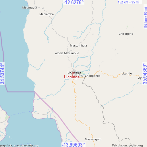
Lichinga GPS coordinates[2]
13° 18' 46.008" South, 35° 14' 26.016" East
| Map corner | latitude | longitude |
|---|---|---|
| Upper-left | -12.6276°, | 34.53744° |
| Center: | -13.31278°, | 35.24056° |
| Lower-right: | -13.99603°, | 35.94369° |
| Map W x H: | 152.2×152.2 km | = 94.6×94.6mi |
| max Lat: | -11.31667° ⇑11.5% North |
| Lichinga: | -13.31278° |
| min Lat: | ⇓88.5% South -25.96553° |
| min Long | Lichinga | max Long |
| 31.99528° | 35.24056° | 40.73583° |
| W 46.2%⇐ | ⇒53.8% E |
Elevation
Elevation of Lichinga is 1349 m = 4426 ft, and this is 1129.5 m = 3706 ft above average elevation for this country.
| Max E: |
1349 m = 4426 ft | 0% |
| Lichinga | 1349 m 4426 ft | |
| Avg. | 219.5 m = 720 ft | |
Min E: |
4 m = 13 ft | 100% |
See also: Lichinga elevation on elevation.city.
Geographical zone
Lichinga is located in South Torrid zone (between Equator and Tropic of Capricorn). Distance of this Southern Tropic circle is 1125.7 km =699.5 mi to South.| Distance of | km | miles | from Lichinga |
|---|---|---|---|
| Equator | 1480.2 | 919.8 | to North |
| Tropic Capricorn | 1125.7 | 699.5 | to South |
| Antarctic Circle | 5920.9 | 3679.1 | to South |
| South Pole | 8526.8 | 5298.3 | to South |


Nearby cities:
5 places around Lichinga: (largest is in red/bold)
• Cuamba
216.8 km =134.7 mi,  139°
139°
• Mandimba
123.8 km =76.9 mi,  159°
159°
• Montepuez
407.4 km =253.1 mi,  87°
87°
• Mutuáli
257.3 km =159.9 mi,  132°
132°
• Tete
362.8 km =225.4 mi,  209°
209°
Sources, notices
• [Note1] Compared only with cities in Mozambique existing in our database
• [Src1] Map data: © OpenStreetMap contributors (CC-BY-SA)
• [Src2] Other city data from geonames.org with taken over terms of usage.
• [Src3] Geographical zone / Annual Mean Temperature by Robert A. Rohde @ Wikipedia
