Tete geodata
Tete is a seat of a first-order administrative division; located in Mozambique in Africa/Maputo (GMT+2) time zone. With population of 129,316 people, there are 7 cities with bigger population in this country. Compared to other cities in Mozambique, 61.5% of cities are located further ↓South; 69.2% of cities are located further →East and 69.2% of cities have lower elevation than Tete. Note1


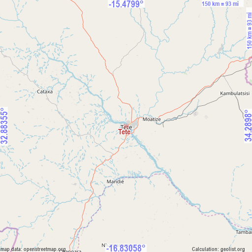
Tete GPS coordinates[2]
16° 9' 23.004" South, 33° 35' 12.012" East
| Map corner | latitude | longitude |
|---|---|---|
| Upper-left | -15.4799°, | 32.88355° |
| Center: | -16.15639°, | 33.58667° |
| Lower-right: | -16.83058°, | 34.2898° |
| Map W x H: | 150.2×150.2 km | = 93.3×93.3mi |
| max Lat: | -11.31667° ⇑38.5% North |
| Tete: | -16.15639° |
| min Lat: | ⇓61.5% South -25.96553° |
| min Long | Tete | max Long |
| 31.99528° | 33.58667° | 40.73583° |
| W 30.8%⇐ | ⇒69.2% E |
Elevation
Elevation of Tete is 137 m = 449 ft, and this is 82.5 m = 271 ft below average elevation for this country.
| Max E: |
1349 m = 4426 ft | 30.8% |
| Avg. | 219.5 m = 720 ft | |
| Tete | 137 m = 449 ft | |
Min E: |
4 m = 13 ft | 69.2% |
See also: Tete elevation on elevation.city.
Geographical zone
Tete is located in South Torrid zone (between Equator and Tropic of Capricorn). Distance of this Southern Tropic circle is 809.5 km =503 mi to South.| Distance of | km | miles | from Tete |
|---|---|---|---|
| Equator | 1796.4 | 1116.2 | to North |
| Tropic Capricorn | 809.5 | 503 | to South |
| Antarctic Circle | 5604.8 | 3482.7 | to South |
| South Pole | 8210.6 | 5101.8 | to South |


Nearby cities:
9 places around Tete: (largest is in red/bold)
• Beira
430.8 km =267.7 mi,  162°
162°
• Chimoio
329.3 km =204.6 mi,  181°
181°
• Chinde
406.9 km =252.8 mi,  131°
131°
• Cuamba
350.1 km =217.5 mi,  64°
64°
• Dondo
403 km =250.4 mi, 162°
• Lichinga
362.8 km =225.4 mi,  29°
29°
• Mandimba
298.7 km =185.6 mi,  47°
47°
• Mutuáli
393.1 km =244.3 mi,  68°
68°
• Quelimane
399.9 km =248.5 mi,  118°
118°
Sources, notices
• [Note1] Compared only with cities in Mozambique existing in our database
• [Src1] Map data: © OpenStreetMap contributors (CC-BY-SA)
• [Src2] Other city data from geonames.org with taken over terms of usage.
• [Src3] Geographical zone / Annual Mean Temperature by Robert A. Rohde @ Wikipedia
