Tienray geodata
Tienray (Limburg) is a populated place; located in Netherlands in Europe/Amsterdam (GMT+2) time zone. With population of 1,040 people, there are 1370 cities with bigger population in this country. Compared to other cities in Netherlands, 81.2% of cities are located further ↑North; 78.9% of cities are located further ←West and 80.4% of cities have lower elevation than Tienray. Note1


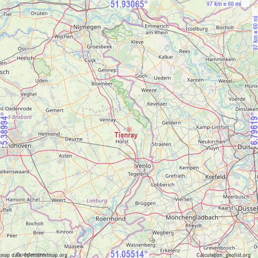
Tienray GPS coordinates[2]
51° 29' 42" North, 6° 5' 35.016" East
| Map corner | latitude | longitude |
|---|---|---|
| Upper-left | 51.93065°, | 5.38994° |
| Center: | 51.495°, | 6.09306° |
| Lower-right: | 51.05514°, | 6.79619° |
| Map W x H: | 97.3×97.3 km | = 60.5×60.5mi |
| max Lat: | 53.48025° ⇑81.2% North |
| Tienray: | 51.495° |
| min Lat: | ⇓18.8% South 50.76917° |
| min Long | Tienray | max Long |
| 3.38611° | 6.09306° | 7.16528° |
| W 78.9%⇐ | ⇒21.1% E |
Elevation
Elevation of Tienray is 21 m = 69 ft, and this is 6 m = 20 ft above average elevation for this country.
| Max E: |
203 m = 666 ft | 19.6% |
| Tienray | 21 m 69 ft | |
| Avg. | 15 m = 49 ft | |
Min E: |
-6 m = -20 ft | 80.4% |
See also: Netherlands elevation on elevation.city.
Geographical zone
Tienray is located in North temperate zone (between Tropic of Cancer and the Arctic Circle). Distance of this North polar circle is 1675.5 km =1041.1 mi to North.| Distance of | km | miles | from Tienray |
|---|---|---|---|
| North Pole | 4281.4 | 2660.3 | to North |
| Arctic Circle | 1675.5 | 1041.1 | to North |
| Tropic Cancer | 3119.8 | 1938.6 | to South |
| Equator | 5725.7 | 3557.8 | to South |


Nearby cities:
15 places around Tienray: (largest is in red/bold)
• Arcen
6.4 km =4 mi,  108°
108°
• Blitterswijck
4.1 km =2.5 mi,  14°
14°
• Broekhuizen
5 km =3.1 mi,  101°
101°
• Broekhuizenvorst
4.4 km =2.7 mi,  90°
90°
• Castenray
4.1 km =2.5 mi,  260°
260°
• Lottum
6 km =3.7 mi,  128°
128°
• Meerlo
2.1 km =1.3 mi,  344°
344°
• Melderslo
3.7 km =2.3 mi,  187°
187°
• Meterik
6.5 km =4 mi,  226°
226°
• Oirlo
4.3 km =2.7 mi,  295°
295°
• Oostrum
6.5 km =4 mi,  305°
305°
• Swolgen
1.8 km =1.1 mi, 99°
• Wanssum
4.7 km =2.9 mi,  345°
345°
• Well
6.1 km =3.8 mi,  357°
357°
• Wellerlooi
5.3 km =3.3 mi,  34°
34°
Sources, notices
• [Note1] Compared only with cities in Netherlands existing in our database
• [Src1] Map data: © OpenStreetMap contributors (CC-BY-SA)
• [Src2] Other city data from geonames.org with taken over terms of usage.
• [Src3] Geographical zone / Annual Mean Temperature by Robert A. Rohde @ Wikipedia
