Lottum geodata
Lottum (Limburg) is a populated place; located in Netherlands in Europe/Amsterdam (GMT+2) time zone. With population of 1,170 people, there are 1297 cities with bigger population in this country. Compared to other cities in Netherlands, 83.3% of cities are located further ↑North; 82% of cities are located further ←West and 80.4% of cities have lower elevation than Lottum. Note1


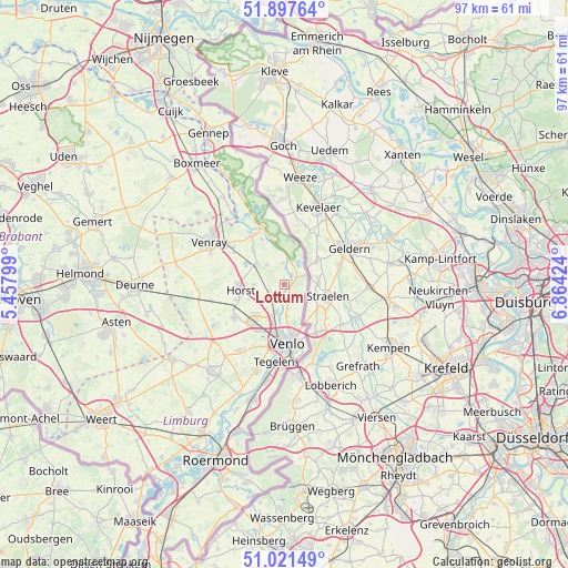
Lottum GPS coordinates[2]
51° 27' 42.012" North, 6° 9' 39.996" East
| Map corner | latitude | longitude |
|---|---|---|
| Upper-left | 51.89764°, | 5.45799° |
| Center: | 51.46167°, | 6.16111° |
| Lower-right: | 51.02149°, | 6.86424° |
| Map W x H: | 97.4×97.4 km | = 60.5×60.5mi |
| max Lat: | 53.48025° ⇑83.3% North |
| Lottum: | 51.46167° |
| min Lat: | ⇓16.7% South 50.76917° |
| min Long | Lottum | max Long |
| 3.38611° | 6.16111° | 7.16528° |
| W 82%⇐ | ⇒18% E |
Elevation
Elevation of Lottum is 21 m = 69 ft, and this is 6 m = 20 ft above average elevation for this country.
| Max E: |
203 m = 666 ft | 19.6% |
| Lottum | 21 m 69 ft | |
| Avg. | 15 m = 49 ft | |
Min E: |
-6 m = -20 ft | 80.4% |
See also: Netherlands elevation on elevation.city.
Geographical zone
Lottum is located in North temperate zone (between Tropic of Cancer and the Arctic Circle). Distance of this North polar circle is 1679.2 km =1043.4 mi to North.| Distance of | km | miles | from Lottum |
|---|---|---|---|
| North Pole | 4285.1 | 2662.6 | to North |
| Arctic Circle | 1679.2 | 1043.4 | to North |
| Tropic Cancer | 3116.1 | 1936.3 | to South |
| Equator | 5722 | 3555.5 | to South |


Nearby cities:
15 places around Lottum: (largest is in red/bold)
• Arcen
2.1 km =1.3 mi,  38°
38°
• Blitterswijck
8.5 km =5.3 mi,  334°
334°
• Boekend
9.8 km =6.1 mi,  198°
198°
• Broekhuizen
2.7 km =1.7 mi,  4°
4°
• Broekhuizenvorst
3.7 km =2.3 mi,  355°
355°
• Castenray
9.3 km =5.8 mi,  289°
289°
• Hegelsom
8.8 km =5.5 mi,  253°
253°
• Meerlo
7.8 km =4.8 mi,  317°
317°
• Melderslo
5.2 km =3.2 mi,  270°
270°
• Meterik
9.5 km =5.9 mi, 265°
• Swolgen
4.5 km =2.8 mi, 318°
• Tienray
6 km =3.7 mi,  308°
308°
• Venlo
10.2 km =6.3 mi,  177°
177°
• Wanssum
10.1 km =6.3 mi, 324°
• Wellerlooi
8.2 km =5.1 mi,  347°
347°
Sources, notices
• [Note1] Compared only with cities in Netherlands existing in our database
• [Src1] Map data: © OpenStreetMap contributors (CC-BY-SA)
• [Src2] Other city data from geonames.org with taken over terms of usage.
• [Src3] Geographical zone / Annual Mean Temperature by Robert A. Rohde @ Wikipedia
