Tholen geodata
Tholen (Zeeland) is a populated place; located in Netherlands in Europe/Amsterdam (GMT+2) time zone. With population of 7,475 people, there are 346 cities with bigger population in this country. Compared to other cities in Netherlands, 78.3% of cities are located further ↑North; 94.8% of cities are located further →East and 58.8% of cities have higher elevation than Tholen. Note1


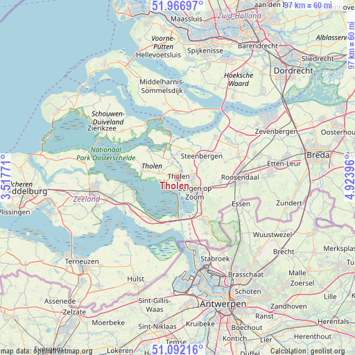
Tholen GPS coordinates[2]
51° 31' 54.012" North, 4° 13' 14.988" East
| Map corner | latitude | longitude |
|---|---|---|
| Upper-left | 51.96697°, | 3.51771° |
| Center: | 51.53167°, | 4.22083° |
| Lower-right: | 51.09216°, | 4.92396° |
| Map W x H: | 97.3×97.3 km | = 60.5×60.5mi |
| max Lat: | 53.48025° ⇑78.3% North |
| Tholen: | 51.53167° |
| min Lat: | ⇓21.7% South 50.76917° |
| min Long | Tholen | max Long |
| 3.38611° | 4.22083° | 7.16528° |
| W 5.2%⇐ | ⇒94.8% E |
Elevation
Elevation of Tholen is 4 m = 13 ft, and this is 11 m = 36 ft below average elevation for this country.
| Max E: |
203 m = 666 ft | 58.8% |
| Avg. | 15 m = 49 ft | |
| Tholen | 4 m = 13 ft | |
Min E: |
-6 m = -20 ft | 41.2% |
See also: Netherlands elevation on elevation.city.
Geographical zone
Tholen is located in North temperate zone (between Tropic of Cancer and the Arctic Circle). Distance of this North polar circle is 1671.4 km =1038.6 mi to North.| Distance of | km | miles | from Tholen |
|---|---|---|---|
| North Pole | 4277.3 | 2657.8 | to North |
| Arctic Circle | 1671.4 | 1038.6 | to North |
| Tropic Cancer | 3123.9 | 1941.1 | to South |
| Equator | 5729.8 | 3560.3 | to South |


Nearby cities:
15 places around Tholen: (largest is in red/bold)
• Bergen op Zoom
6.4 km =4 mi,  129°
129°
• Halsteren
3.3 km =2.1 mi,  96°
96°
• Heerle
9.7 km =6 mi, 98°
• Lepelstraat
4.3 km =2.7 mi,  64°
64°
• Nieuw-Vossemeer
6.5 km =4 mi,  358°
358°
• Noordgeest
4.7 km =2.9 mi,  121°
121°
• Oud-Vossemeer
4.6 km =2.9 mi,  340°
340°
• Poortvliet
5.6 km =3.5 mi,  284°
284°
• Scherpenisse
8.1 km =5 mi, 281°
• Sint Philipsland
10.2 km =6.3 mi, 337°
• Steenbergen
9 km =5.6 mi,  49°
49°
• Welberg
9.1 km =5.7 mi, 56°
• Wouw
11.8 km =7.3 mi, 95°
• Wouwse Plantage
12.7 km =7.9 mi,  114°
114°
• Yerseke
12.6 km =7.8 mi,  249°
249°
Sources, notices
• [Note1] Compared only with cities in Netherlands existing in our database
• [Src1] Map data: © OpenStreetMap contributors (CC-BY-SA)
• [Src2] Other city data from geonames.org with taken over terms of usage.
• [Src3] Geographical zone / Annual Mean Temperature by Robert A. Rohde @ Wikipedia
