Welberg geodata
Welberg (North Brabant) is a populated place; located in Netherlands in Europe/Amsterdam (GMT+2) time zone. With population of 1,410 people, there are 1174 cities with bigger population in this country. Compared to other cities in Netherlands, 75.3% of cities are located further ↑North; 93.1% of cities are located further →East and 65.8% of cities have higher elevation than Welberg. Note1


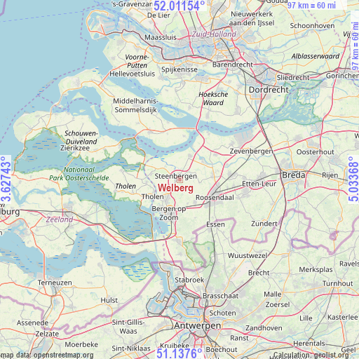
Welberg GPS coordinates[2]
51° 34' 36.012" North, 4° 19' 50.016" East
| Map corner | latitude | longitude |
|---|---|---|
| Upper-left | 52.01154°, | 3.62743° |
| Center: | 51.57667°, | 4.33056° |
| Lower-right: | 51.1376°, | 5.03368° |
| Map W x H: | 97.2×97.2 km | = 60.4×60.4mi |
| max Lat: | 53.48025° ⇑75.3% North |
| Welberg: | 51.57667° |
| min Lat: | ⇓24.7% South 50.76917° |
| min Long | Welberg | max Long |
| 3.38611° | 4.33056° | 7.16528° |
| W 6.9%⇐ | ⇒93.1% E |
Elevation
Elevation of Welberg is 3 m = 10 ft, and this is 12 m = 39 ft below average elevation for this country.
| Max E: |
203 m = 666 ft | 65.8% |
| Avg. | 15 m = 49 ft | |
| Welberg | 3 m = 10 ft | |
Min E: |
-6 m = -20 ft | 34.2% |
See also: Netherlands elevation on elevation.city.
Geographical zone
Welberg is located in North temperate zone (between Tropic of Cancer and the Arctic Circle). Distance of this North polar circle is 1666.4 km =1035.5 mi to North.| Distance of | km | miles | from Welberg |
|---|---|---|---|
| North Pole | 4272.3 | 2654.7 | to North |
| Arctic Circle | 1666.4 | 1035.5 | to North |
| Tropic Cancer | 3128.9 | 1944.2 | to South |
| Equator | 5734.8 | 3563.4 | to South |


Nearby cities:
15 places around Welberg: (largest is in red/bold)
• Bergen op Zoom
9.5 km =5.9 mi,  196°
196°
• Dinteloord
7 km =4.3 mi,  22°
22°
• Halsteren
6.9 km =4.3 mi,  218°
218°
• Heerle
6.7 km =4.2 mi,  162°
162°
• Hulsdonk
9.6 km =6 mi,  126°
126°
• Kruisland
5.5 km =3.4 mi,  98°
98°
• Lepelstraat
4.9 km =3 mi,  229°
229°
• Nieuw-Vossemeer
7.9 km =4.9 mi,  280°
280°
• Noordgeest
8.3 km =5.2 mi,  205°
205°
• Oud Gastel
9 km =5.6 mi,  82°
82°
• Oud-Vossemeer
9.1 km =5.7 mi,  265°
265°
• Stampersgat
8.9 km =5.5 mi,  62°
62°
• Steenbergen
1.1 km =0.7 mi,  317°
317°
• Tholen
9.1 km =5.7 mi,  236°
236°
• Wouw
7.4 km =4.6 mi,  145°
145°
Sources, notices
• [Note1] Compared only with cities in Netherlands existing in our database
• [Src1] Map data: © OpenStreetMap contributors (CC-BY-SA)
• [Src2] Other city data from geonames.org with taken over terms of usage.
• [Src3] Geographical zone / Annual Mean Temperature by Robert A. Rohde @ Wikipedia
