Stokkum geodata
Stokkum (Overijssel) is a populated place; located in Netherlands in Europe/Amsterdam (GMT+2) time zone. With population of 730 people, there are 1585 cities with bigger population in this country. Compared to other cities in Netherlands, 61.3% of cities are located further ↓South; 88.8% of cities are located further ←West and 70.6% of cities have lower elevation than Stokkum. Note1


Stokkum GPS coordinates[2]
52° 12' 42.012" North, 6° 30' 24.984" East
| Map corner | latitude | longitude |
|---|---|---|
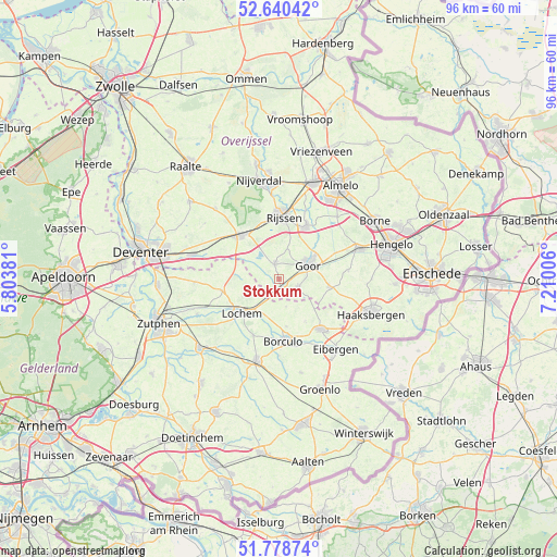
| Upper-left | 52.64042°, | 5.80381° |
| Center: | 52.21167°, | 6.50694° |
| Lower-right: | 51.77874°, | 7.21006° |
| Map W x H: | 95.8×95.8 km | = 59.5×59.5mi |
| max Lat: | 53.48025° ⇑38.7% North |
| Stokkum: | 52.21167° |
| min Lat: | ⇓61.3% South 50.76917° |
| min Long | Stokkum | max Long |
| 3.38611° | 6.50694° | 7.16528° |
| W 88.8%⇐ | ⇒11.2% E |
Elevation
Elevation of Stokkum is 15 m = 49 ft, and this is 0 m = 0 ft above average elevation for this country.
| Max E: |
203 m = 666 ft | 29.4% |
| Stokkum | 15 m 49 ft | |
| Avg. | 15 m = 49 ft | |
Min E: |
-6 m = -20 ft | 70.6% |
See also: Netherlands elevation on elevation.city.
Geographical zone
Stokkum is located in North temperate zone (between Tropic of Cancer and the Arctic Circle). Distance of this North polar circle is 1595.8 km =991.6 mi to North.| Distance of | km | miles | from Stokkum |
|---|---|---|---|
| North Pole | 4201.7 | 2610.8 | to North |
| Arctic Circle | 1595.8 | 991.6 | to North |
| Tropic Cancer | 3199.5 | 1988.1 | to South |
| Equator | 5805.4 | 3607.3 | to South |


Nearby cities:
15 places around Stokkum: (largest is in red/bold)
• Barchem
10.7 km =6.6 mi,  204°
204°
• Bentelo
12.1 km =7.5 mi,  83°
83°
• Borculo
10.7 km =6.6 mi,  174°
174°
• Diepenheim
3.6 km =2.2 mi,  111°
111°
• Elsen
6.8 km =4.2 mi,  18°
18°
• Geesteren
8.2 km =5.1 mi, 170°
• Goor
5.9 km =3.7 mi,  65°
65°
• Hengevelde
8.9 km =5.5 mi,  98°
98°
• Laren
9.8 km =6.1 mi,  258°
258°
• Lochem
8.8 km =5.5 mi,  228°
228°
• Loo
12.3 km =7.6 mi,  291°
291°
• Markelo
2.7 km =1.7 mi,  347°
347°
• Neede
11.3 km =7 mi,  139°
139°
• Wiene
10.2 km =6.3 mi, 75°
• Zeldam
9.7 km =6 mi,  58°
58°
Sources, notices
• [Note1] Compared only with cities in Netherlands existing in our database
• [Src1] Map data: © OpenStreetMap contributors (CC-BY-SA)
• [Src2] Other city data from geonames.org with taken over terms of usage.
• [Src3] Geographical zone / Annual Mean Temperature by Robert A. Rohde @ Wikipedia
