Bentelo geodata
Bentelo (Overijssel) is a populated place; located in Netherlands in Europe/Amsterdam (GMT+2) time zone. With population of 730 people, there are 1585 cities with bigger population in this country. Compared to other cities in Netherlands, 62.7% of cities are located further ↓South; 93.1% of cities are located further ←West and 74.9% of cities have lower elevation than Bentelo. Note1


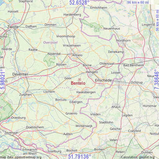
Bentelo GPS coordinates[2]
52° 13' 27.012" North, 6° 40' 59.988" East
| Map corner | latitude | longitude |
|---|---|---|
| Upper-left | 52.6528°, | 5.98021° |
| Center: | 52.22417°, | 6.68333° |
| Lower-right: | 51.79136°, | 7.38646° |
| Map W x H: | 95.8×95.8 km | = 59.5×59.5mi |
| max Lat: | 53.48025° ⇑37.3% North |
| Bentelo: | 52.22417° |
| min Lat: | ⇓62.7% South 50.76917° |
| min Long | Bentelo | max Long |
| 3.38611° | 6.68333° | 7.16528° |
| W 93.1%⇐ | ⇒6.9% E |
Elevation
Elevation of Bentelo is 18 m = 59 ft, and this is 3 m = 10 ft above average elevation for this country.
| Max E: |
203 m = 666 ft | 25.1% |
| Bentelo | 18 m 59 ft | |
| Avg. | 15 m = 49 ft | |
Min E: |
-6 m = -20 ft | 74.9% |
See also: Netherlands elevation on elevation.city.
Geographical zone
Bentelo is located in North temperate zone (between Tropic of Cancer and the Arctic Circle). Distance of this North polar circle is 1594.4 km =990.7 mi to North.| Distance of | km | miles | from Bentelo |
|---|---|---|---|
| North Pole | 4200.3 | 2609.9 | to North |
| Arctic Circle | 1594.4 | 990.7 | to North |
| Tropic Cancer | 3200.9 | 1988.9 | to South |
| Equator | 5806.8 | 3608.2 | to South |


Nearby cities:
15 places around Bentelo: (largest is in red/bold)
• Borne
9.7 km =6 mi,  27°
27°
• Bornerbroek
9.7 km =6 mi,  348°
348°
• Delden
4.4 km =2.7 mi, 25°
• Diepenheim
9.1 km =5.7 mi,  252°
252°
• Elsen
11.1 km =6.9 mi,  297°
297°
• Goor
6.7 km =4.2 mi,  278°
278°
• Haaksbergen
8.4 km =5.2 mi,  153°
153°
• Hengelo
8.8 km =5.5 mi,  58°
58°
• Hengevelde
4.3 km =2.7 mi,  229°
229°
• Klein Driene
10.3 km =6.4 mi, 60°
• Neede
11.1 km =6.9 mi,  205°
205°
• Rietmolen
9.4 km =5.8 mi,  188°
188°
• Wiene
2.5 km =1.6 mi, 298°
• Woolde
7.4 km =4.6 mi,  43°
43°
• Zeldam
5.2 km =3.2 mi,  314°
314°
Sources, notices
• [Note1] Compared only with cities in Netherlands existing in our database
• [Src1] Map data: © OpenStreetMap contributors (CC-BY-SA)
• [Src2] Other city data from geonames.org with taken over terms of usage.
• [Src3] Geographical zone / Annual Mean Temperature by Robert A. Rohde @ Wikipedia
