Sassenheim geodata
Sassenheim (South Holland) is a populated place; located in Netherlands in Europe/Amsterdam (GMT+2) time zone. With population of 15,510 people, there are 221 cities with bigger population in this country. Compared to other cities in Netherlands, 62.8% of cities are located further ↓South; 88.4% of cities are located further →East and 58.8% of cities have higher elevation than Sassenheim. Note1


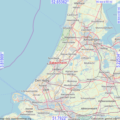
Sassenheim GPS coordinates[2]
52° 13' 30" North, 4° 31' 19.992" East
| Map corner | latitude | longitude |
|---|---|---|
| Upper-left | 52.65362°, | 3.81909° |
| Center: | 52.225°, | 4.52222° |
| Lower-right: | 51.7922°, | 5.22534° |
| Map W x H: | 95.8×95.8 km | = 59.5×59.5mi |
| max Lat: | 53.48025° ⇑37.2% North |
| Sassenheim: | 52.225° |
| min Lat: | ⇓62.8% South 50.76917° |
| min Long | Sassenheim | max Long |
| 3.38611° | 4.52222° | 7.16528° |
| W 11.6%⇐ | ⇒88.4% E |
Elevation
Elevation of Sassenheim is 4 m = 13 ft, and this is 11 m = 36 ft below average elevation for this country.
| Max E: |
203 m = 666 ft | 58.8% |
| Avg. | 15 m = 49 ft | |
| Sassenheim | 4 m = 13 ft | |
Min E: |
-6 m = -20 ft | 41.2% |
See also: Netherlands elevation on elevation.city.
Geographical zone
Sassenheim is located in North temperate zone (between Tropic of Cancer and the Arctic Circle). Distance of this North polar circle is 1594.3 km =990.7 mi to North.| Distance of | km | miles | from Sassenheim |
|---|---|---|---|
| North Pole | 4200.2 | 2609.9 | to North |
| Arctic Circle | 1594.3 | 990.7 | to North |
| Tropic Cancer | 3201 | 1989 | to South |
| Equator | 5806.9 | 3608.2 | to South |


Nearby cities:
15 places around Sassenheim: (largest is in red/bold)
• Abbenes
4.9 km =3 mi,  76°
76°
• Binnenhof
6.8 km =4.2 mi,  171°
171°
• De Engel
2.1 km =1.3 mi,  29°
29°
• Hoogmade
7.4 km =4.6 mi,  146°
146°
• Lisse
4.6 km =2.9 mi, 31°
• Lisserbroek
4.9 km =3 mi,  44°
44°
• Merenwijk
5.5 km =3.4 mi,  189°
189°
• Nieuwe Wetering
6.8 km =4.2 mi,  106°
106°
• Noordwijk-Binnen
5.4 km =3.4 mi,  280°
280°
• Noordwijkerhout
4.5 km =2.8 mi,  334°
334°
• Oegstgeest
6.2 km =3.9 mi,  215°
215°
• Rijnsburg
6.7 km =4.2 mi,  234°
234°
• Rijpwetering
5.5 km =3.4 mi,  130°
130°
• Voorhout
2.6 km =1.6 mi,  261°
261°
• Warmond
3.4 km =2.1 mi,  202°
202°
Sources, notices
• [Note1] Compared only with cities in Netherlands existing in our database
• [Src1] Map data: © OpenStreetMap contributors (CC-BY-SA)
• [Src2] Other city data from geonames.org with taken over terms of usage.
• [Src3] Geographical zone / Annual Mean Temperature by Robert A. Rohde @ Wikipedia
